


After two months in China (see previous post), I returned to Paris to reunite with Mathieu. It’d been over 4 months since we were together in Cambodia (see previous post) so I was super happy to see him again. During my 3-month stay with him, we took a trip to the beautiful country of Iceland.
Per Wikipedia, the Republic of Iceland (Lýðveldið Ísland in Icelandic) is a Nordic island country in the North Atlantic Ocean. It has a population of 329,100 (of which 207,174 live in Reykjavík) and an area of 40,000 sq mi (103,000 sq km) making it the most sparsely populated country in Europe. The settlement of Iceland began in the 9th century when the Norwegian chieftain Ingólfr Arnarson became the first permanent settler on the island. In the following centuries, Norwegians, and to a lesser extent other Scandinavians, immigrated to Iceland, bringing with them thralls of Gaelic origin.
About 85 percent of total primary energy supply in Iceland is derived from domestically produced renewable energy sources (primarily geothermal and hydrroelectric) and Iceland ranks among the top 10 greenest economies in the world. Iceland still relies heavily on fishing, including whaling, but its importance has diminished from 90% in the 1960s to 40% in 2006.
Iceland is volcanically and geologically active. The interior consists of a plateau of sand and lava fields, mountains and glaciers, and glacial rivers that flow to the sea through the lowlands. Iceland is warmed by the Gulf Stream and has a temperate climate, despite a high latitude just outside the Arctic Circle. Its high latitude and marine influence still keeps summers chilly, with most of the archipelago having a tundra climate.
So what did I do for nearly 4 weeks in the land of fjords, glaciers, volcanoes, lava fields, and waterfalls? Explore and trek of course, taking full advantage of the summer season’s midnight sun!
By the time our flight landed and we picked up the rental car, it was 2am, so we decided to find a nice place several miles away from the airport to park and spent our first “night” in Iceland sleeping in the car. Thank goodness we were prepared for the 24-hour daylight and had our eye masks. The next morning, we pushed up our masks to welcome a cool but mostly sunny day.
The first stop was Reykjavík to stock up on groceries and explore the city. The small capital city (population 207,174) was bustling with tourists checking out the numerous charming shops selling trinkets, souvenirs, fancy outdoor gear, and all things made of Icelandic wool. The Euro 2016 Championship had started June 10th and lucky for us, there was a football (aka soccer) match that day: Iceland vs. Hungry. So after meandering around the city, window shopping, checking out the waterfront, etc… we joined a few hundred spectators bundled up in the city’s main square to watch the football match on a jumbotron. It was cool to be in a sea of blue (jerseys, hats, scarves, face paint, etc…). Despite the drizzling rain that started shortly before the match, we had a great time singing, laughing, drinking beer, and cheering with the fans. The match ended in a tie (1-1) but the fans were happy. It was a great first day in Iceland!!
From Reykjavík, we spent a few days slowly making our way north on Roads 47 and 54, following the contours of the fjords, stopping along the way to marvel at the many waterfalls and rivers, then drove around Snæfellsjökull, a magnificent 700,000-year-old glacier-topped volcano located at the tip of long, narrow peninsula. Per Wikipedia, the volcano is one of the most famous sites of Iceland, primarily due to the 1864 Jules Verne novel, Journey to the Center of the Earth, in which the protagonists find the entrance to a passage leading to the center of the earth on Snæfellsjökull.
From there, we continued further north on Road 60 to explore the lesser-traveled Westfjords, stopping first at Látrabjarg, the westernmost point in Iceland and Europe’s largest bird cliff, ~9 mi (14 km) long and up to 1,443 feet (440 m) high. These cliffs are home to millions of birds, including northern gannets, guillemots, razorbills, and puffins! Per Wikipedia, this site hosts up to 40% of the world population for some of these species. It was amazing to finally see puffins for my first time! Adorable. We also watched a brown arctic fox run on the trail ahead of us searching for bird nests to poach on the cliff edge. The arctic fox, brown in summer and white in winter, is Iceland’s only native terrestrial mammal which came to the island at the end of the ice age, walking over the frozen sea. The view overlooking the sparkling ocean below was stunning, especially on such a gorgeous, sunny day. Along with seeing puffins and an arctic fox, the day was extra special (and extra long) since it was June 21, the summer solstice. I decided to stay up to watch the sunset on the longest day of the year. I bundled up, sat on a boulder on the beach near our campsite, listened to music, and waited. And waited. And waited. Finally at about 1:20am, the sun went below the horizon. Wow, it truly was a summer solstice to remember. (Note: I heard the next day from fellow campers that the sun rose again about two hours later. Crazy!)
As we prepared to continue our roadtrip, we met Gail and Terrence, a French couple who were hitchhiking around Iceland. Together we traveled along the small roads of the Westfjords, stopping at various waterfalls, viewpoints overlooking gorgeous inlets and bays, and small quaint towns. It was great to meet some fellow travelers and Mathieu was very happy to have some fellow French-speakers to chat with. After a few days, we said farewell to them in the village of Ísafjörður but luckily ran into them a few more times along our route in northern Iceland.
After walking around Ísafjörður (population 2,600) and enjoying a nice meal, including some Icelandic beer, we returned to our parked car to find it sitting in a pool of fluid. Apparently the fuel hose broke while we were driving on the dirt arounds along the fjords (not F roads, just regular dirt roads). This happens so frequently that this type of repair, along with cracked windshields, is not covered by the rental car insurance. Our friendly neighborhood police officer who’d been waiting by the car, called the rental car company for us and arranged for a tow truck to take the car about three blocks to a local garage. It was after 10pm on a Thursday, so we’d have to wait until the next day for the repairs. While waiting for the tow truck, we were joined by another police office and a fire truck with three fireman who cleaned up the spilt diesel fuel. Mathieu, all three firemen, and one of the police officers crawled under the car to confirm that the puddle was due to a broken fuel hose. So, there we were on the corner of this small village with our little rental car surrounded by two police officers, three firemen, a fire truck with lights flashing, and a few onlookers. We had the feeling we were the excitement for the night. The next day, we hitched a ride to the garage and paid our repair bill (about $250, mostly due to the after-hours towing). After a stop at a bakery to help us forget about the bill, we drove to Drangajökull, the northernmost glacier of Iceland. Per Wikipedia, the glacier covers an area of ~67 sq mi (200 sq km) and is the only Icelandic glacier which lies entirely below an altitude of 3,280 ft (1,000 m) and is also the only glacier that has not shrunk in recent years. The glacier-cut valley was stunning with numerous small waterfalls flowing down the steep sides and into the thundering river that flowed out of the massive glacier. Besides a few other hikers, we had the valley and the glacier to ourselves. After the hike, we drove to the tiny fishing village of Drangsnes, where we enjoyed the evening rain while soaking in a communal (aka free) hot tub overlooking a small bay. It was a great way to end the day and let go of any remaining stress over the costly car repairs.
From there, we continued our scenic drive east along Road 68 to Siglufjörður, a fishing village located at the end of a fjord, offering lovely views overlooking the ocean. After a night there, we rejoined Route 1, known as Iceland’s Ring Road encircling the entire country for over 800 mi (1,287 km). We stopped at Goðafoss, a large waterfall, and Mývatn, a lake that per Wikipedia was created by a large basaltic lava eruption 2300 years ago. Being on the very popular Ring Road, we shared these sites with numerous tour buses and an army of fellow tourists. However, both the waterfall and the lake were beautiful and like in most places, if you’re willing, as we were, to walk a few miles past the trailhead, you can escape the masses. After a nice day hike up a volcanic crater, through the lava fields around the lake, and through a piping hot geothermal area, we arrived to our destination for the night: Dettifoss. Per Wikipedia, Dettifoss is the largest waterfall in Iceland with an average water flow of 193 m3/s, and the most powerful waterfall in Europe. The water comes from the nearby Vatnajökull glacier, whose sediment-rich runoff colors the Jökulsá, Iceland’s second longest river, a greyish white. The falls are 330 ft (100 m) wide and have a drop of 144 ft (44 m) resulting in an impressive thundering noise and crashing spray. It was a truly awesome sight! From the waterfall, we continued north on Roads 865/85 north and east to the fishing village of Þórshöfn, enjoying the dramatic views of the land meeting the sea along the way.
From Þórshöfn, we drove south on Road 85 along the coast, entering the less-traveled east Iceland via Hellisheiði pass (Road 917). It was an adventure driving over Iceland’s highest (2,152 ft (656 m)) and steepest pass, and to add to the adventure, it was cold and super foggy, with nearly zero visibility. After camping for the night at a lovely spot below the pass, we drove Road 94 to the end of the Borgarfjörður Eystri fjord to visit the cliffs crammed with breeding fulmars, kittiwakes, eiders, and puffins! After watching puffins fly out to sea to fish, return with fish, pop below ground into their nests, reemerge, and watching them just look adorable, we drove south on Roads 94 and 93 to Seyðisfjörður, a charming village surrounded by mountains. Per Wikipedia, the town is well known for its old wooden buildings and has a vibrant cultural scene with an arts centre, a Technical Museum, a local heritage museum, and the only two cinemas in the east of Iceland. There are also a few restaurants and bars, one of which we visited to have a beer and watch another football match: Portugal vs. Poland (Portugal won, making the team’s single fan in the bar very happy and the Icelanders very unhappy).
The next day, we drove the short distance to Egilsstaðir to pick up my brother Jabal, who flew from San Francisco to Reykjavík then to Egilsstaðir to join us. We’d last hung out in October 2015 in Antwerp, Belgium, so I was super excited to see him. After many big hugs, we took a scenic drive on Road 910 toward the Vatnajökull ice cap. We tried to remain positive and to ignore the wind and rain but finally we had to abort our plans to camp in the area and return from where we came and away from the foul weather. We ended up finding a good campsite overlooking Lagarfljót lake. We spent the night singing, dancing, chatting, and scanning the lake’s surface to catch a glimpse of Lagarfljótsormurinn, a cryptic serpent believed by some to live in the depths of Lagarfljót. Unfortunately despite our efforts, none of us saw the reputed serpent. Hmm….maybe a few more Icelandic beers and shots of the Irish whiskey Jabal had brought would have helped our chances. Ha!
The next day, we hiked along the Jökulsá River, accompanied by two very friendly herding dogs. It was a little rainy and cold but the river and surrounding valley were gorgeous and we had the trail to ourselves. We even got to cross the river via a bucket bridge, literally a 1-person bucket that is manually moved across the river on cables via a pulley system. It was very cool until the rope fell off the pulley wheel, leaving Mathieu on one side of the river and Jabal and I on the other. Luckily it didn’t happen while one of us was suspended over the thundering river! Jabal and I only had to walk a few miles (in the cold rain) to a bridge where Mathieu met us in the car.It was a fun adventure. The next day, we returned to Egilsstaðir and said farewell to Mathieu who had to return home and back to work. Thankfully, I’d be rejoining him in Paris after 9 more days in Iceland, so it was farewell only for a short time.
From Egilsstaðir, Jabal and I continued south on Road 92 to Reyðarfjörður where, at the end of the road, we did a great day hike. It was cold and wet but the views were absolutely amazing. We were surrounded by snow-covered mountains on three sides and overlooked the inlet of Reyðarfjörður, a massive inlet that looked even more dramatic with white-caps and shadows from the passing storm clouds. After setting up the tent at the campground in Reyðarfjörður, we went to a bar to watch another football match: Iceland vs. France. This was a quarter-final match for the Euro 2016 Championship and the fans in the small bar were pumped! With beers in hand, we settled in to watch the game with the locals. The two teams seemed pretty well matched at first (in my very novice opinion), with each team spending about the same amount of time near the goal. But that all changed when France scored their first goal about 12 minutes into the match. Then, shortly after, they scored another goal, then another followed quickly by another. So by the half, France was winning 4-0. The mood in the bar was somber but still hopeful. I was bummed for Iceland but was secretly cheering for both teams: Iceland because they were the underdogs and France because they were Mathieu’s team. Jabal, however, was really bummed out and didn’t want to watch the second half, so we left. We found out the next day from the campground hostess that France scored another goal during the second half but that Iceland also scored 2 more goals, making the final score 5-2 France. She was very proud of her team for making it to the finals. I read later in The Reykjavík Grapevine, a humorous, free alternative magazine, that this was the first time since the foundation of the Icelandic Football Association in 1947 that the team had ever qualified for the finals of a major tournament. No wonder the country was so excited that their team had made it to the quarterfinals. Good job Iceland!!!
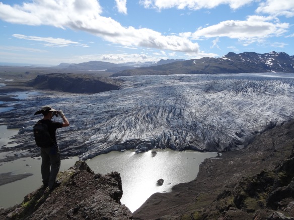
The next day was clear and sunny (but still cold) so we decided to return to Road 910 to try again to get closer to the Vatnajökull ice cap. Per Wikipedia, Vatnajökull is the largest and most voluminous ice cap (aka miniature ice sheet) in Iceland, and the second largest ice cap in area in Europe (the first being in Norway). To get a better look at the massive ice cap, we did a 2-night backpacking trip around 6,014-ft (1,833-m) high Snæfell mountain, northeast of the glacier. While the weather during our trek was mostly cold, drizzly, and cloudy, and my feet got soaked crossing the numerous marshy areas at the foot of the mountain, the views of Snæfell, the surrounding mountains, and the distant Vatnajökull were amazing. Thankfully, we had a few periods of sun during which the various colors of the volcanic rock we walked over and the sparse vegetation in the area came alive. On the morning of day three, we hiked up mount Snæfell, stopping just below the summit. It was a sunny day (at least for a few hours) and the views overlooking the marshy valley between the mountain and Vatnajökull and of the expansive ice cap itself were breathtaking. And the storm clouds around us and over the ice cap added to the dramatic scene. It was one of my favorite sights in Iceland, and except the four people we encountered on our way down the mountain and back to the car, we had the trek to ourselves. Amazing! After the trek, we continued south, enjoying the changing views of the impressive Vatnajökull ice cap for about 100 mi (160 km) as we continued along the coast on the Ring Road.
Over the next few days, we stopped at various spots to day hike along the Skálafellsjökull and Breiðamerkurjökull glaciers, tongues of Vatnajökull ice cap. It was amazing to get up close and personal with these massive glaciers. We also stopped at the very popular Jökulsárlón lagoon where icebergs from Vatnajökull calve into the glacial lagoon. We joined the masses to watch as small icebergs floated out of the mouth of the lagoon into the ocean. It was a cool sight. From there, we continued along the Ring Road to Vík, the southernmost village of Iceland. Being only 110 mi (180 km) from Reykjavík and on the easily accessible Ring Road, the campground in the small village was packed with tents, RVs, and campervans. However, since the wifi was good, the showers were hot, and the communal kitchen was huge, it was a good place to spend a few rainy days. We’d been mostly lucky with the weather so far, with some sunny days and some days of only light rain.
After two days of relaxing, reading, journaling, and exploring the cliffs and black-sand volcanic beaches around Vík, we continued west on the Ring Road then to Road 26 where we crossed valleys of ancient lava flows and small volcanoes to get to Hekla (4,892 ft (1,491 m)), one of Iceland’s most active volcanos with over 20 eruptions in and around the volcano since 1104. The most recent eruption occurred in February 2000 and thankfully caused no damage. At the junction of Road 26 and Road F-225, we parked, able to go no further in our non-4X4 rental car. Lucky for us, we met Herman “the German” and Emmet (also German), who gave us a ride in their 4X4 to the trailhead. They’d taken the car ferry from Denmark to tour around Iceland for two weeks. We folded ourselves into the car among the camping gear, food, and mountain bikes and off we went to the trailhead. It was a bumpy and uncomfortable 5-6 mile ride but it beat walking. We ended up hiking up the volcano with our new friends, all of us enjoying the magnificent views of the looming snow-capped volcano above and the surrounding lava-covered valley below. It was cool to see tiny flowers growing out of the jagged volcanic rock that covered the ground. The day started out cloudy but dry, then changed quickly as we neared the summit, becoming rainy with some snow, windy, and foggy. It was so foggy at times, I could barely see my hand stretched out in front of my face. Oh crap, time to abort the summit attempt and get off the volcano. Trying to find the trail in the very cold, foggy conditions was really difficult and I finally understood how people got lost in this type of weather. Thankfully, the four of us worked together to stay on the trail and we made it back to the car unscathed. As we said farewell to our German friends, they gave us some really good German beer. It was perfect after a death-defying hike. Ha!
The next day, we drove west to Þingvallavatn, Iceland’s largest natural lake. Per Wikipedia, the Eurasian and North American tectonic plates meet in this area which we could see from the deep cracks and faults around the lake. Thanks to a local at the lake’s visitor center, we found a hike to the summit of a small mountain overlooking the lake. The hike went past numerous thermal vents and a steaming hot, sulfurous creek. We had the trail to ourselves. At the summit, we had a great view of the huge lake, the river flowing from the lake to the ocean, Hekla volcano in the distance, and Reykjavík. The sun, partially covered by a few clouds, was behind Reykjavík, casting a lovely light on the land in between. On the way down, we were treated to a gorgeous double rainbow over the lake. It was a fabulous end to the last day of the road trip.
After our last night wild camping, we returned to Reykjavík, where Jabal and I shared a delicious dinner at a cozy restaurant and a beer at a local bar before saying farewell. I returned to Paris and he enjoyed a few more days in Reykjavik.
Iceland is a beautiful country with varied amazing landscapes and very friendly people, 99.9% of whom speak excellent English. Traveling around the country is easy, wild camping is allowed, and for those who prefer facilities, there are numerous campgrounds, most with wifi. While we were there during the high tourist season (mid June thru August) and the south part of the island was very crowded, we saw relatively few other tourists in the Westfjords and in the north and east parts of the island (away from the Ring Road). I definitely want to visit this amazing country again, and when I do, I’ll rent a 4X4 so I can explore the interior highlands via the infamous F-Roads.
The nearly 4 weeks I spent exploring the beautiful landscapes of Iceland were amazing. I was thrilled to tent camp the entire time, sometimes off the beaten path and and sometimes at campgrounds (with hot showers!). But of course, my experience was even more memorable because I got to share it with people I love, Mathieu and Jabal. Thank you both for all the amazing memories.
Here are a few pictures. Click the link to see the full album: https://goo.gl/photos/ybqarwVE9gAWcwt89
Enjoy!
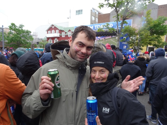
- Watching fooball in Reykjavik. Go Iceland!

- Latrabjarg cliffs.

- Puffins!

- Summer solstice sunset:

- With Terrence and Gail at Dynjandi waterfalls.
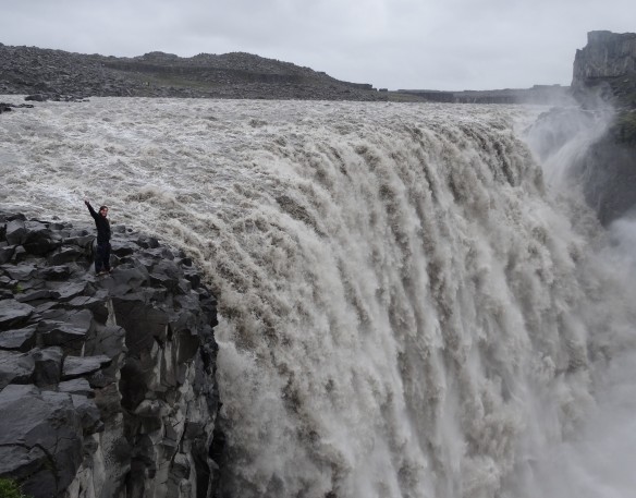
- Dettifoss. Wow!

- Icelandic beer and Irish whiskey near Lagarfjot lake.
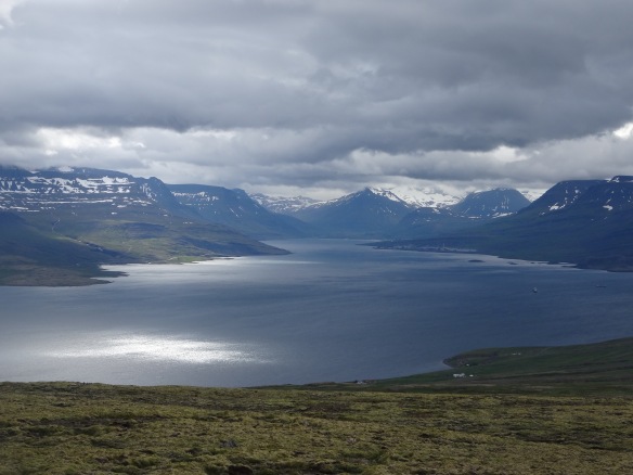
- Overlooking Reydarfjordur inlet.

- Trailhead to Snaefell mountain.

- View from Snaefell mountqin, overlooking Vatnajokull ice cap.
- Overlooking Skalafellsjokull glacier.
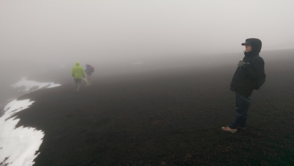
- Near the summit of Hekla Volcano.

- Silly in Reykjavik.

- Last sunset in Iceland. Farewell. Until next time.

Well it looks like another fabulous experience. Your writing and pictures paint a wonderful and exciting time for you, Mathieu and Jubal. So happy to see yall having such a great adventure. Looks like fun exploration. Tons of that stuff, DAD
LikeLike
Thanks dad! And thanks for ready my blog and for always supporting me. xoxo
LikeLike