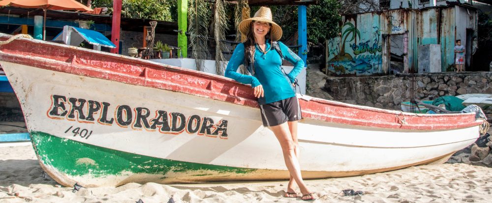
After 14 days exploring beautiful mountains and cities big and small in the states of Mexico, Hidalgo, Queretaro, Guanajuato, and Zacatecas with Mathieu’s mom, Marie (see previous post), Mathieu and I continued our road trip north through the interior of Mexico. We spent the next 16 days exploring the states of Zacatecas, Durango, Chihuahua, and Sonora.
Click HERE to go directly to the full photo album or click “Continue reading” to read more about our road trip adventure through this part of Mexico!
After taking Marie to the bus station in Zacatecas for her return trip to Mexico City (and to Paris a few days later), we decided to have Genevieve’s brake pads replaced; they’d started making the tell-tell grinding noise. We stopped at AutoZone (found throughout Mexico) and asked about a local mechanic. Within 15 minutes, a 16-year old kid arrived, jumped in the truck with us and guided us to his uncle’s shop located in the nearby neighborhood. We described to Ernesto, the uncle/shop owner, what we wanted done and within 15 minutes, the 16-year old had Genevieve jacked up on the narrow street and the mechanic began changing the pads. The old pads were worn to almost nothing; I’d definitely gotten my money’s worth! He also cleaned the rear brakes, checked the engine, and added fluids as needed. He worked on the truck for about 2 hours and our bill, including parts and labor, was 700 pesos or ~$36. Wow. They were also very nice and didn’t seem to mind us chatting with them and looking over their shoulders as they worked. With the brake job done, we drove north on Ruta 45 for about an hour to the city of Fresnillo where we found a cheap hotel for the night.
The next morning, we continued north a few hours to Parque Nacional Sierra de Órganos. The scenery on that stretch of road was flat and mostly scrub so not very interesting. Thankfully as we approached the Park, we could see the towering rock formations of the Sierra Madre Occidental mountain range, which per Wikipedia, are reminiscent of organ pipe cactuses or the pipes of the musical instrument, from which the park takes its name. The area was beautiful. After setting up our tent in the small campground, I relaxed in the shade of the trees and Mathieu went for a bike ride to explore. Even from our camp site, the view of the tall rock pillars around us was awesome, especially in the setting sun. That night, we met a group of 4-5 college students camping in the vicinity but otherwise enjoyed the starry night all to ourselves.
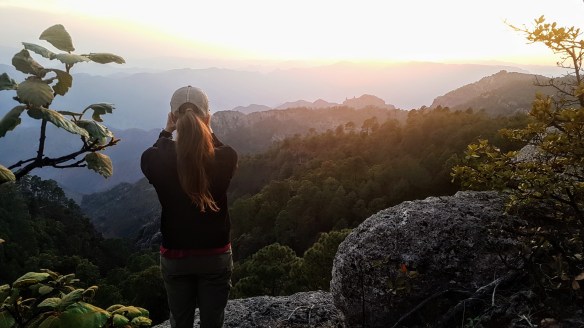
We woke up the next morning to watch the sun’s light spread across the mountains. It was lovely. We hiked the well-marked trails through the formations, going through desert scrub then up through pine/oak forest, marveling at the scenery around us, and at the fact that we had the park to ourselves. It was a really remarkable place and the views from the tops of the mountains were stunning. After the hike, we drove north on a secondary road then on Ruta 40, crossing into the state of Durango. After about 3 hours driving through more flat scrublands, we arrived to a picnic area along the Rio Nazas (Nazas River) that we’d read about on iOverlander. There was a fair amount of trash around but the view of the steep, rugged mountain raising up from the other side of the rive was beautiful. After picking up trash, we took a swim, washed some clothes, and enjoyed a cold beer at our riverside camp. After the sun set, the family that had been swimming and picnicking nearby left and we enjoyed another starry night to ourselves.
From there, we continued north on Ruta 49, stopping in a small town along the way for lunch. After eating some delicious tacos and buying some groceries, we got back into the truck to continue. As I backed up, Mathieu suddenly yelled “stop!” He could see in his side mirror that I was backing into a metal pole. Oops. Then as I slowly moved forward, we both heard a strange noise and got out to investigate. Somehow when I backed up into the low, 3-ft high metal pole, the pole had caught the wheel of my bike. So, as I pulled forward, my bike was stretched between the pole and the truck, not only stretching the tire, but also bending the bike’s frame beyond repair. Crap. The incident had also bent the very sturdy metal pole. Oops. To make matters worse, a group of 5 or 6 local guys who’d been talking on the opposite corner watched the whole thing and were laughing. Argh. We tried to straighten the metal pole with no success, then, not knowing what else to do, we resecured my mangled bike on the bike rack and got back on the road. Both bikes had been through hell on this road trip: the tires had been punctured a few times by massive cactus spines, they’d been drug behind the truck when Mathieu forgot to reattach the bike rack, and they’d been rattled and covered in dirt over the thousands of rough miles we’d driven. The bikes had survived the previous incidents but it was clear that after this latest incident, my bike was finished. Too bad I hadn’t ridden it more.
We shook it off and continued north to the Reserva de la Biósfera de Mapimí. The site is also referred to as a “Zona del Silencio” (Zone of Silence) which per the internet has a reputation as an area in which various as yet unexplained natural events occur, such as the loss of radio waves, an increased solar radiation that is 35% greater than in other parts of the planet, the strange coloration and structure of many plants, the existence of turtles with strange shells and the frequent fall of meteorites. Needless to say, the Reserve, along with its beautiful desert landscape, sounded like a very interesting place to visit. However, after a 30-minute drive on a small dirt road, we arrived to the visitor center but it was closed. After looking around some, we found the gate that lead into the Reserve but it was locked. It appeared to be a place that required reservations to visit. Oh well, next time. So, we returned to the main road and continued north on Ruta 49 then west of Ruta 45, crossing into the state of Chihuahua. After the city of Hidalgo del Parral, we drove west on a secondary road. Most of the drive that day had been through uninteresting landscapes so we were happy when the terrain began to change and we could see mountains again in the distance. We stopped for the night at a cheap hotel in the small town of San Pablo Balleza. We definitely needed a proper shower and a cold beer after this somewhat stressful and unsuccessful day.
After a leisurely morning, we continued west on a secondary road to the small town of Yoquivo where we turned off onto a small dirt road and into the mountains. It was great to be on another off-the-beaten-path road. We steadily climbed up the mountain, marveling at the landscape around us. We found a small spot on the side of the road to camp, arriving just in time to watch the sun set over the stunning canyons below. We were now overlooking the southwestern end of Parque Nacional Barranca del Cobre (Copper Canyon National Park).
Per Wikipedia, Barrancas del Cobre is a group of canyons consisting of six distinct canyons in the Sierra Madre Occidental, each formed by a different river which merge and eventually empty into the Gulf of California. The walls of the canyons are a copper/green color, which is where the name originates. The canyons are home to the Tarahumara (or Rarámuri), Native Americans who originally inhabited much of the state of Chihuahua but who retreated to the high sierras and canyons in the Sierra Madre Occidental (i.e., Copper Canyon) when Spanish invaders arrived in the 16th century. They typically inhabit areas that are too remote for city people, way off-the-beaten-path, to remain isolated and independent, so as to avoid losing their culture. They are known or their long-distance running ability, often traveling great vertical distances by running nonstop for hours.
I’d known about Copper Canyon for some years from various sources but I’d first read about the Tarahumara in Christopher McDougall’s book, Born to Run, in which he describes his time with these renowned long-distance runners and argues in favor of barefoot running. So I was very excited to finally have the chance to visit these canyons and meet its interesting inhabitants.
We woke up at our roadside camp site to watch the sunlight spread across the canyons and the distance mountains. It was a wonderful way to start the day. After breakfast we continued west, passing only cows on the narrow dirt road to the small town of Batopilas (population ~1,200), a Pueblo Magico located along the Batopilas River. We explored the quaint town for a bit and visited the small museum where a very chatty ancient man held me captive as he explained the town’s long history as a silver mining town. After the history lesson, we drove the narrow, dirt road out of the valley and up the other side. Just before sunset, we found another small spot off the road to camp and enjoyed another amazing sunset overlooking the stunning landscape spanning many miles in front of us.
After enjoying another beautiful sunrise, we continued driving down the mountain to the small town of Urique (population ~1,100). We strolled along the main street, only a few blocks long, then had a delicious lunch. The town was very quiet with only a few locals around. We then drove up and down a few more mountains, through a few more valleys and small towns (i.e., Bahuichivo and San Rafael), marveling at the amazing views all along the way. As we enjoyed the drive, we tried not be stressed at the fact that none of the small towns we encountered so far had gas stations. The gas gauge was nearing “E” and by this time, we’d already added the spare fuel from the 2-gallon tank we carried. Thankfully, just before sunset, we arrived to the tiny settlement of Areponápuchi, consisting of a few dozen houses, a church, a few hotels, and a grocery store. We were told there was a gas station but couldn’t find it. After asking yet another person, we finally saw the small, crudely-painted sign on the side of the street reading “gasolina.” We drove into what appeared to be someone’s backyard. There were a dozen or so people hanging out, listening to music, and drinking beer. We thought we were in the wrong place but quickly spotted the large drums of gas. It was fun to be in the middle of such a festive atmosphere while the gas was being funneled into the tank. Now fueled up, we used Maps.me to follow a small unnamed dirt road along the lip of the canyon in hopes of finding a place to camp. As was becoming our custom, we found another great camp site just off the road. But this one was extra special because, after only a short walk, we could peer into Barranca del Cobre (Copper Canyon), the deepest of the six canyons in the Park with a depth of 5,906 ft (1,800 m).
The next morning, as we prepared to hike into the canyon, we were visited by three Tarahumara children on their way to school. They likely lived in the small house down the canyon we’d seen the night before. They stood within about 20 feet (6 m) and just watched us. After some time trying to make conversation (we hoped the Tarahumara language was similar to Spanish), they finally started to answer some of our simple questions. What’s your name? How old are you? Is that your brother? After a bit, they even agreed to take pictures with me. The boys wore modern clothing but the little girl wore a more traditional Tarahumara outfit with a colorful headscarf and colorful skirt. All three children wore the traditional huarache sandals.
After they left for school, we followed a nearby trail along the side of the canyon that took us to a cluster of small Tarahumara houses built into the side of the cliff. The brick houses were small and simple but the view from the front doors was amazing. After hiking further, we came to a trail sign that lead us to Parque de Aventura Barrancas del Cobre, an adventure park with a teleférico (gondola) into the canyon and offering activities such as ziplining, a ropes course, and an adventure course that includes crossing several suspension bridges hanging over the deep canyons. We walked along the rim trail overlooking the canyons then visited the glass-walled visitor center/restaurant at the edge of the cliff. We watched as the teleférico descended into the canyon below. It was a pity that this development had been constructed on the canyon rim but it looked like a nice ride. Thankfully, besides the adventure park and its large hotel, there appeared to be little other large-scale development in this area of the park.
After investigating the adventure park, we hiked on the Ruta El Canon down the steep, rocky trail to a small cluster of Tarahumara houses. We didn’t see any people but it was interesting to see their homes. We then ascended up a steep trail to the teleférico station where we encountered a sign that informed us, in Spanish and English, that “the canyon system is four times in extent (60,000 sq km) and nearly twice as deep in depth as the Grand Canyon of Colorado.” Wow, twice as deep as the Grand Canyon of…..Colorado? We assumed they were referring to the Grand Canyon in Arizona that had been cut by the Colorado River. Also, the comparison of depth of the Grand Canyon with the depth of the Copper Canyon system seemed a bit like comparing apples and oranges but whatever, the canyons in front of us were deep, expansive, and amazing. We continued our hike to Nido de Aguila (Eagle’s Nest), a massive rock formation towering above the canyon. The wind on the canyon-side of the formation was extraordinarily strong, almost pushing us backwards! While I think the Grand Canyon is much deeper, the Copper Canyon system appears to be more expansive and is equally spectacular.
To return to camp, we followed Ruta Panoramica which, per its name, offered expansive views over the canyons. Throughout the day, the only other people we passed on the trails were a handful of Tarahumara. It was fascinating to envision living in these deep, rocky canyons only accessible by pack animal or by foot. And every Tarahumara person we passed wore the traditional huarache sandals which consisted of a thin sole (of leather or automobile tire tread) attached to the foot with a thin strap (of leather or synthetic material). Wow. After the hike, we drove back into Areponápuchi for a well-deserved dinner at one of the few restaurants then spent the evening at our campsite watching the full moon illuminate the canyons below. It’d been a great day exploring the canyons and getting a glimpse into the life of its local residents.
We woke up early again to watch the sun as it started to rise from behind the distant mountains. With the layers of clouds overhead, it was an especially dramatic scene. As we packed, our new friends visited us again on their way to school. This day they were more shy and watched us from behind a small tree. Mathieu gave them chocolate granola bars through the branches and they left for school while munching away. We then drove back to the adventure park. After hiking down into the canyons the day before, we’d decided we had to explore them from above.
The zipline adventure consisted of a series of seven tirolesas (ziplines) that would take us from a height of 7,874 ft (2400 m) to over halfway to the canyon floor. I guess it was low season because the adventure park was empty and we had two guides to ourselves for our zipline adventure. For nearly 2.5 hours, we rode the seven ziplines, speeding over several deep canyons. Even the shortest zipline, #2 at 462 ft (141 m) long was fun but of course the longest zipline, #5 at 3,651 ft (1113 m) long was the fastest and most exhilarating. I’d ziplined only once before, taking a very short ride over a pool of water in a pitch-black cave in New Zealand. That was fun but this was awesome! At the end, we took the teleférico back up the canyon, enjoying our last views of the Park’s deepest canyon then drove north to Agua Thermales de Rekowata, privately-owned hot springs located at the bottom of a deep, narrow canyon. Since it was after 5pm and the hot springs were closed, we camped at Mirador Rekowata, a viewpoint overlooking the canyons. It was a beautiful spot to enjoy more amazing views over the deep canyons below.
The next morning, we drove the short distance to Agua Thermales, parked, then walked down the extremely steep, roughly cobbled road that switch-backed down the canyon to the pools. Other than the caretaker, we were the only people there. The site consisted of man-made pools into which hot spring water was piped. None of the pools were quite hot enough but they were still very enjoyable. As we soaked, Enrique arrived. He was a Mexican on a 3-month adventure backpacking through Mexico. It was fun to chat with him and swap stories about travels in his country. After a long soak, the three of us walked back up the steep road then drove north to Creel. From there, Enrique took a bus back south to Parque de Aventura Barrancas del Cobre where he would work for a few weeks as a zipline guide (what a coincidence!). While the small town of Creel (population ~5,000) is Copper Canyon’s main tourism center, we stayed only long enough to buy some groceries and get gas before driving south to Cascada de Cusarare, at the northeastern side of the Park.
Cascada de Cusarare is a 98-ft (30-m) tall waterfall, and according to our guidebook, is considered one of the most beautiful in Mexico. Walking past the long row of permanent tables on the way to the fall, it was apparent that the site is a tourist attraction, likely drawing hundreds of visitors. However, during our visit, there were only a few tables filled with handicrafts being sold by local Tarahumara women. As we approached the fall, it made sense that we were the only tourists there. It was the dry season and the fall consisted of a trickle of water. We’d seen pictures of the fall so knew its glory when gushing with water. Oh well, the view of the pool below the fall and of the canyon beyond was very nice. As we took pictures and lamented about not seeing the fall at its full potential, we were joined by two Tarahumara kids. Like the kids we’d met before, they stood close and stared at us. We asked them some questions but only got “si” (yes) in response every time. As we crossed the tiny river to view the fall from the other side, we motioned for them to come with us. They seemed happy to be invited. After a bit, I started playing a game with them criss-crossing the river by jumping from stone to stone. They picked up on the game instantly and we laughed as we took turns racing across the river while trying to keep our feet dry. After playing with the kids and enjoying the scenery for a bit, we drove north, leaving Parque Nacional Barranca del Cobre, and arriving to Lago Arareko. We’d read on iOverlander that along with a campground, the lake was apparently surrounded by interesting rock formations. We set up camp next to the lake and relaxed for the evening with no one else camping nearby.
After breakfast the next morning, we went for a hike to investigate the rock formations. We passed a few small houses and grazing cows and goats as we followed a well-worn path over the hill and down into the next valley. After a short distance, we came to the small community of San Ignacio de Arareko where we visited the Misión San Ignacio, a small, simple Jesuit mission built in 18th century. After the church, we visited the rock formations in El Valle de los Hongos, de las Ranas y de los Monjes (the valley of the mushrooms, the frogs, and the monks). While seeing these clusters of very large boulders situated in an otherwise flat, featureless landscape was interesting, they were not as extraordinary as described in our guidebook. The “mushroom” formations were easy to visualize but if there hadn’t been signs onsite with pictures of the “frog” and the “monk”, we would not have seen the resemblance. Regardless, it was fun to check out the huge rocks and try to imagine them as different objects. We also spent some time browsing the handicrafts laid out on several long, unmanned tables nearby. The colorful baskets, dolls, pottery, trinkets, etc… were handmade by local Tarahumara girls and women and offered a bit more insight into their culture.
After browsing and playing with an adorable puppy who’d joined us at the handicrafts tables, we continued walking to la Cueva San Sebastian. Per the internet , the cave has been inhabited for 300 years and is named for Don Sebastian, the last patriarch living there who died at the age of 105. The cave is currently inhabited by eight direct descendents of Don Sebastian and is one of the only caves in the area allowing tourists to enter. With approval from an ancient woman living nearby, we entered the cave for a glimpse of Tarahumara life. The cave, which was more of a deep cavity than a cave, had a short rock fence and a wooden gate by which to enter. There was a simple kitchen area with a fire pit, a few wood cabinets for housewares, and several flat areas where sleeping mattresses were laid. The ceiling was black from the decades of fires to cook and provide warmth. The ancient woman who allowed us into the cave answered our questions as we explored the “house” but was otherwise uninterested in talking to us. She had an amazing face and we wished we could hear her stories. After buying some hand-made souvenirs and stealthily taking pictures of her, we continued our hike, following the locals trail over a steep, rocky hill, then passing a cemetery with colorful, plastic flowers and streamers, to get to Creel. After a short look around the town, we walked back to camp and enjoyed the sunset over the lake.
From the lake, we drove north on Ruta 23 to Parque Nacional Cascada de Basaseachi. The road was paved and in good condition for the almost 3-hour drive. We turned off the main road to go to a mirador where we overlooked a wide, steep-sided canyon and the Cascada de Basaseachi, the second highest waterfall in Mexico at 807 ft (246 m). Similar to the last fall we’d visited, there wasn’t much water, and given the height of the fall, the water became mist before reaching the bottom. Nevertheless, the view was awesome! Mathieu and I enjoyed the sunset from the mirador, sharing it only with one other couple. With the sun gone, it got cold so we set up camp. We’d gotten the OK from the park guard to camp in the parking lot for the night. He assured us we’d be safe since he locked the gate each night and reopened it each morning. The parking area had flush toilets, benches, a covered cabana, and a few picnic sites with tables and BBQs. It was a great place to camp, and we had it all to ourselves.
We both woke up very early the next day to see the sunrise over the deep canyon. It was cold but worth it. After breakfast, we went for a hike down to the base of the waterfall. The trail, paved at first, went straight down with only a few switchbacks. We went through pine/oak forest on the way down to the large and deep pool below the fall. With the pool in the shade it was way too cold to swim so we hiked a short distance along the river then climbed back up the steep trail to enjoy the view from the mirador again.
From the waterfall, we drove Ruta 16, going first through pine-forested mountains for some miles then through rolling hills covered with oak savannah. The land was very dry but still very pretty, given the reddish leaves of the dry trees and the yellow of the dry grass. We also passed huge rock formations and steep cliffs. At the small town of San Rosa, now in the state of Sonora, we turned north onto Ruta 117 and continued to the smaller town of Arivechi, the first town we came to with a hotel. The room was dumpy and way overpriced, but we were hot and tired, having driven for 5 hours, and it had air conditioning. We took a short walk through the tiny ranching town then returned to the hotel where we joined two other guests to drink our cold beers on the porch. It’d been a long, hot day so the cold beers tasted especially delicious.
The next day, we continued north on Ruta 117, known as la Ruta de la Sierra. The views of the dry mountains, river valleys, rocky canyons, and rock formations were stunning. In unison, we’d both say “wow” every few miles on the curvy road. At the town of Moctezuma, we stopped for delicious tacos then continued west on Ruta 14 then north on Ruta 89, now on the Ruta Rio Sonora. The road went through a huge valley along the Sonora River. Throughout the day we passed only ranchos, tiny settlements, and small towns and a few dozen vehicles, mostly pickup trucks. It was a wonderful drive. We stopped in the town of Baviacora to see, per our guidebook, Sonora’s most beautiful church. It was a concrete church with river rock decorating some of the walls. It was pretty but somewhat not the most beautiful we’d seen.
As we left town, we passed a long line of pickup trucks driving slowly in the opposite direction followed by a few dozen cowboys, and a few cowgirls, on horseback. We asked a cowboy what was happening. Despite not understanding his explanation, we asked if we could watch, and he told us where to go. We parked, grabbed a beer from our cooler (since the cowboys had been riding with beers in hand) and walked to the unknown event. We both hoped it was a rodeo and Mathieu was giddy in anticipation since it would be his first.
After a few blocks, we came to the gathering. The cowboys, still on horseback, were gathered behind a basketball court on which rows of people were seated in folding chairs, everyone facing two men standing behind a long table with speakers on either side. Although farfetched, I still hoped it was the opening ceremony for a rodeo that would take place nearby. We stood to the side with the few men holding beer cans and waited. It turned out to be Sunday church service. No wonder the men were trying to be discreet with their beers. Oh well, at least Mathieu got to see a bunch of real cowboys.
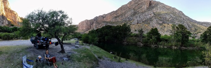
Back on the road, we continued to the small town of Arizpe. We’d read on iOverlander about a public picnic/camping area on a small river. It turned out to be very crowded with locals drinking beer and listening to music next to their giant pickups. It was obvious that everyone knew each other and that families and friends gathered there regularly. The vibe was friendly and festive but we decided to find a quieter place to camp. Following a nearby dirt road, we found a lovely, quiet camp spot along the small river. After driving ~186 mi (300 km) that day, it was the perfect place to relax and enjoy the warm evening. With cold beers in hand, we toasted our home for the night and enjoyed our last night of camping in Mexico.
The next morning, we packed up slowly. We were in no hurry to leave this lovely little spot, especially since from there, we would drive to the Mexico/US border. This would be our last full day in Mexico. We walked along the river and through the narrow canyon nearby. It was a nice area and so peaceful. Finally at about noon, when there was no more shade, we got back on the road. We continued north on Ruta 118, then west of Ruta 2, then north on Ruta 196, purposely taking small roads as we drove to the border. We continued to have nice views for most of the drive, going through the large river valley then winding through the mountains. However, as we approached the border, the landscape became scarred with large mines (likely copper) so was not so nice. After driving ~ 124 mi (200 km) that day, we arrived to the large border city of Nogales (population ~212,500).
While in Nogales, we decided to have some vehicle maintenance done. After asking around, we were directed to “Multiservicios El Giro” owned and operated by Manuel, a mechanic who’d lived in the US for 15 years before returning to Mexico. He changed Genny’s oil, replaced the fried battery cables (see previous post) and flushed the radiator. He told us that the seal on the radiator cap had disintegrated and that the cap needed to be replaced. We made plans to buy a new radiator cap (a $10 part) that afternoon, then promptly forgot. We spent a few hours at the shop, talking to him as he worked on the truck and watching cartoons with his young son in the office. When finally finished, our bill was 700 pesos ($36) for parts and labor. Wow.
From there, we went to a nearby hotel. It was a dump but it was cheap and convenient. After relaxing for a bit, we walked around the area for about an hour, passing stores, businesses, restaurants, grocery stores, gas stations, etc…some local but many chain stores. We were on the outskirts of the city and it was not a pretty walk but at least we got a little exercise. Back at the hotel, we watched a movie in bed, both falling asleep fairly early. It was not an exciting last night in Mexico, but we were tired and it was nice to just relax.
The next morning, we made breakfast in our room then slowly packed up, finally leaving at noon. We then drove to the border. Upon leaving Mexico, we needed to return our vehicle permit. We’d gotten the permit in La Paz (Baja) and had paid a deposit of $200 which would be refunded when we exited Mexico. I’d read several blogs describing the permit return process so felt well prepared. However, as we approached the border, I never saw any signs that would lead us to the Mexican immigration office. Instead we ended up in the line to cross back into the US. Crap. After a 15-minute wait, the US border agent took our passports. Before we could even ask him about the permit return, he informed us that Mathieu, being a French citizen, had to get a new visa in order to re-enter the US. He showed us where to park and walked us to the office. Thankfully it was a painless process. With his new 90-day US visa in hand, we made a U-turn to re-enter Mexico to search for the Mexican immigration office. It turned out the office was at a location referred to as “KM 21”, literally 21 km (13 mi) south of Nogales. Thankfully the process to return the vehicle permit and get the refund was fast and painless. We then drove the 21 km back to the border. This time, instead of a 15 minute wait, we waited 45 minutes to cross the border. Crap. By now, we were a bit frustrated and tired but we spent the time in the long line of slow-moving vehicles listing all of the extraordinary places we’d visited and the amazing experiences we’d had in Mexico. We’d listed only a fraction by the time it was our turn to cross the border back into the US.
During our nearly 5-month road trip through Baja and mainland Mexico, we drove roughly 11,000 mi (17,700 km). We camped 93 nights (71 nights wild camping (aka free) and 22 nights in paid campgrounds), stayed with friends for 12 nights, and stayed in hotels 35 nights (the most expensive being 500 pesos, ~$26). We were constantly stunned by the variety of amazing landscapes throughout the country: deserts, beaches, huge mountain ranges, massive glacier-topped volcanoes, turquoise-colored waterfalls and rivers, and deep canyons, and by the beautiful wildlife inhabiting these areas. We also enjoyed the various cultures, artwork, music, and, of course, the food! The people we met throughout our trip, locals, other travelers, and old friends, made the trip exceptional. And, we felt safe the entire time. I hope to return to Mexico again in the future; there’s so much more of this wonderful country to explore! Adios Mexico, hasta pronto.
Here are a few pictures. Click the link to see the full album: https://photos.app.goo.gl/vdBNZXKDhQ18nQEF3
Enjoy!
[Next post: Cuba. Stay tuned!]

Mathieu overlooking Parque Nacional Sierra de Órganos.

Another amazing camp site in Copper Canyon National Park.

The Tarahumara kids who visited our camp site.

Overlooking Copper Canyon, the deepest of the six canyons in the Copper Canyon National Park.
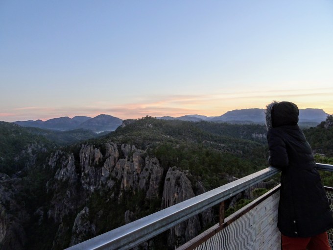
Overlooking Copper Canyon.

Sunrise from our camp site overlooking Copper Canyon.
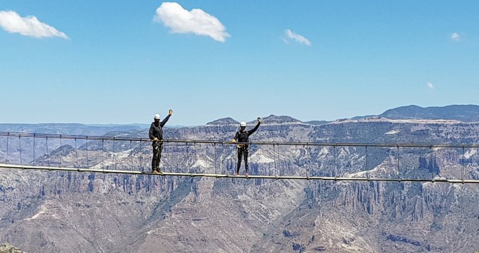
Ready for adventure in the Copper Canyon adventure park.

Ready to zip over the canyons on the longest of the seven ziplines in the Copper Canyon adventure park.

The view of Copper Canyon National Park from our camp site at Mirador Rekowata.

Soaking in the hot springs at Agua Thermales.

Mathieu and a couple Tarahumara kids enjoying the view at Cascada de Cusarare.

The morning view from our camp site at Lago Arareko.
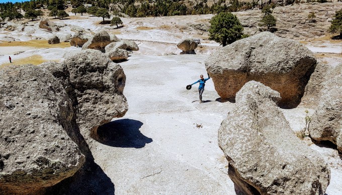
Among the formations in the Valle de los Hongos.
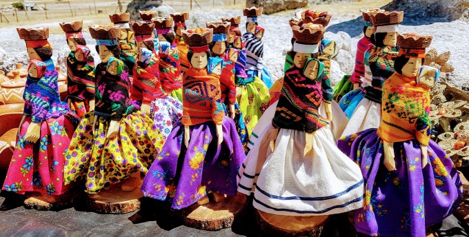
Handmade Tarahumara dolls for sell near the Valle de los Hongos.
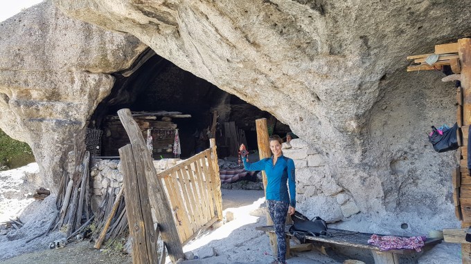
An attempt to stealthily take a picture of the Tarahumara woman we met in San Sebastian Cave.

The amazing face of the Tarahumara woman in San Sebastian Cave.
Overlooking Parque Nacional Cascada de Basaseachi at sunset.

Cascada de Basaseachi (Basaseachi Waterfall) in the dry season.

The morning view from our tent of the peaceful, secluded camp site near Arizpe

Sunday church service in Baviacora.

Excited to wake up here on our last morning camping in Mexico.

What an amazing experience you are having – thank you for sharing, I am living vicariously thru you!
LikeLike
Hi Susan, I hope you’re doing well. Thanks so much for reading my blog and for your comment! I’m glad you’re enjoying the stories : )
LikeLike