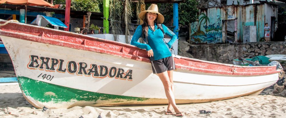

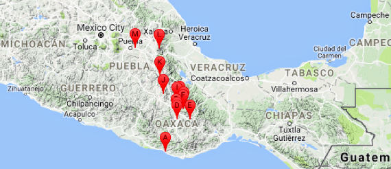
After 18 days exploring the beautiful waterfalls, mountains, and beaches in the states of Campeche, Chiapas, and Oaxaca (see previous post), Mathieu and I continued our road trip through Mexico, spending the next 9 days exploring the interior of the state of Oaxaca and returning to the state of Puebla.
Click HERE to go directly to the full photo album or click “Continue reading” to read more about our road trip adventure through this part of Mexico!
After a wonderful night camping on a secluded beach near Puerto Escondido, we said farewell to the Pacific Ocean and drove north on Ruta 131 through the Sierra Madre del Sur mountains. The scenery through the forested mountains was beautiful. As we continued further north, we noticed that the number of cars going south increased and that most of them had flower wreaths and/or a picture of the Virgin Mary on the front grill. It was the day before Semana Santa (aka Holy Week or Easter Week), one of Mexico’s most important and widely celebrated holiday seasons. The small altars were intended to ensure the travelers arrived to their designations safely. We hoped the protective blessings extended to us and Genevieve (my 4Runner) as we continued on the curvy, 2-lane mountain road. After a long 163-mi (263-km) drive, we arrived safely to the city of Oaxaca (population ~4 million). Once in our hostel, we relaxed on the rooftop terrace, ate dinner, and watched a lightning storm in the distance. For dinner, we had tlayudas (a large thin, toasted tortilla covered with a spread of beans, meat, Oaxaca cheese, and salsa) made by two sisters at a tiny restaurant nearby. It was a delicious introduction to Oaxaca, a city known for its distinctive traditional cuisine.
The next day, we explored the city center, a UNESCO World Heritage Site for its historic buildings and monuments. We visited the central plaza, enjoying the flowers and fountains, and strolled along the shop- and restaurant-lined streets surrounding the plaza. It was Palm Sunday, the first day of Semana Santa, so the streets were packed with people (mostly domestic), many carrying crosses and bouquets made of palm leaves to celebrate the special day. Next we visited several of the large, ornate churches in town, including the beautiful Catedral Metropolitana de Nuestra Señora de la Asunción (1733); all of them were packed with people. We also visited two art museums housing contemporary and traditional, local artwork. Per Wikipedia, Oaxaca is one of the few Mexican states characterized by the continuance of its ancestral crafts. This includes the barro negro (“black mud”) pottery and hand-carved wooden alebrije sculptures produced locally. I enjoyed all of the artwork, but I was especially captivated by the intricate designs of the traditional pieces.
In the afternoon, we joined the crowd in the plaza to enjoy a large orchestra playing beautiful classical music. I loved watching the orchestra’s conductor who never stopped smiling as he enthusiastically waved his arms in the air, leading his musicians in song. After the wonderful music, we went to the Mercado 20 de Noviembre, a huge market filled with food stalls, selling fresh bread, beautiful produce, dried fruits and spices, meats and cheese, cooked food, and more. We picked one of the dozens of small restaurants and tried some of Oaxaca’s famous mole, of which there are six different types. I ordered the mole negro (black) and Mathieu ordered the mole rojo (red) both of which were served over chicken and rice, with tortillas on the side. Both were rich and absolutely delicious. Mole is one of my favorite Mexican dishes and I was in heaven! Thank goodness they gave us tortillas to wipe the remaining mole off the plate or I would have embarrassed Mathieu when I licked my plate clean. We spent the rest of the day walking through the small streets of the city and window shopping in the small markets. That evening, we returned to the central plaza. This time, there was a live band playing upbeat dance music. I always love a band with an accordion! People were dancing, kids were running around and playing with glow-in-the-dark toys, and everyone was enjoying the night. It was so cool to be part of the festive vibe.
The next day, we drove south on Ruta 175 to the small town of San Bartolo Coyotepec (population ~8,000), the birthplace of barro negro pottery made from the black clay found in the area. Per Wikipedia, the black pottery, known for its color, sheen, and unique designs, continues to be handmade by 600 families in San Bartolo Coyotepec and the surrounding area. We first visited the workshop of Doña Rosa, the local potter who in the 1950s developed the technique to give the fired black clay a metallic sheen. She continued to make pottery until she died in 1980 at the age of 80. Her workshop, now run by her family, is well known for its high quality pieces and is heavily visited.
From there, we visited some of the smaller workshops along the same street. After examining the pottery in three or four shops, we began to see the differences in quality. While many of the vases, candle holders, small pots, figurines, etc. were of a similar general shape and design, the quality and precision of the fine lines and cuts in the pottery varied greatly. After walking through a few more workshops, we started to return to Doña Rosa’s shop which we decided had the superior pottery. On our walk back, we stopped in one last shop we’d missed previously. The workshop of Doña Mariana was, like the others, small with floor-to-ceiling shelves packed with black pottery. However, we could see immediately that the design quality was excellent (in our now-expert opinions). As we examined the pottery, we chatted with Doña Mariana and her husband, also a potter. We held up pieces and they explained how they were made. Their work was beautiful. In total, we bought eight pieces, paying 750 pesos, about $42. After a quick online search later, we found similar pieces selling for $50 each. Wow! Of course, the best part of our shopping experience was talking to the potters and buying the pottery directly from them at their workshop located in the birthplace of the craft.
From San Bartolo Coyotepec, we drove the short distance to San Martin Tilcajete, a small town (population ~1,800) known for its alebrijes, handcarved, handpainted wooden folk art sculptures of fantastical creatures. Per Wikipedia, the first alebrijes were made by Pedro Linares in the 1930s who, while very ill and unconscious in bed, dreamt of a strange forest with trees, rocks, and clouds that suddenly transformed into strange, unknown animals such as a donkey with butterfly wings, a rooster with bull horns, a lion with an eagle head, and all of them shouting “alebrijes.” When he recovered, he began recreating the creatures from his dream in cardboard and papier-mache and called them Alebrijes. In the 1980s, after gaining much popularity, Linares demonstrated his papier-mache designs to local artisans in the Oaxaca valley area, one of whom adapted the designs to the wood-carved animals traditionally made in the valley.
Similar to the barro negro pottery, I’d always wanted to buy one or two of these fantastical creatures and was excited at the prospect of buying them in the area where they were made. When we arrived to San Martin Tilcajete, there was an alebrije-specific market set up in the small town’s central plaza. We walked from stall to stall slowly examining the pieces and talking to some of the artists. Similar to the pottery, after a few stalls, we could really see the difference in the quality of the pieces. Of course, the pieces painted with more fine lines and details were the most expensive. Some of the large, elaborately-painted pieces took the artist over 6 months to complete. One such large piece, a colorful, intricate iguana, cost 40,000 pesos, about $2,265. Even some of the small, finely-painted pieces cost 4,000 pesos, about $225. I quickly realized that I would NOT be buying an alebrije that day. I’d always wanted a large, detailed piece so would have to wait until it was in my budget. Oh well, it was a great experience meeting the artists and learning more about the creation of these whimsical creatures. And now I had another reason to return to Oaxaca in the future.
After our shopping spree, we left the Oaxaca area and drove Ruta 190 east to Hierve el Agua, natural formations of petrified calcium carbonate that resemble cascades of water falling up to 295 ft (90 m) to the valley below. We camped in a large dirt parking lot with an amazing view of the “falls” and the valley below that we shared with only a handful of neighbors. We had a lovely night overlooking the valley as it was illuminated by the light of the rising full moon.
The next morning, we woke up as the sun rose over the valley and distant mountains. It was spectacular. We walked down the hill to the natural pools feeding the falls. The reflections of the morning sky on the crystal-clear water was amazing. We then took a short hike into the valley and under the petrified waterfalls. On our way back to the campsite, we walked past the people in the campervan that had been parked near us the night before. It was Jacob and Connie and their dog, Filu! They were an Austrian/German couple we’d taken a tour with at the monarch butterfly reserve (see previous post) in January. We exchanged stories about what we’d seen and done since meeting then made plans to visit them in Queretaro, the city north of Mexico City where they lived. It was so cool to see people we knew! And, we’d see them again soon.
After Hierve el Agua, we continued north on another curvy mountain road to the tiny town of Latuvi (population ~290) located along the Ruta Sierra Juarez, an ecotourism route known for its natural beauty and recreational opportunities. After a stop at the tourism office to get camping and trail information, we drove down a small, curvy road, passing a few houses and farm fields, to the grassy camping area next to a small tree-lined creek. The area was beautiful and peaceful, and it was near the start of the Camino Real trail, the trek we planned to do the next day. As we were relaxing and enjoying the cool temperature [~68F (20C) at 6,560 ft (2000 m)], Samuel Contreras, a local farmer stopped by on his walk home from work. He was carrying a large piece of wood, apparently part of the manual till pulled by ox to rotate his fields, He was very happy to chat with us, telling us about his farm and what we could expect to see on your upcoming hike. It’s always a treat when we get to met our neighbors.
The next day, we hiked the Camino Real trail to the tiny town of Lachatao. We followed the creek most of the way then climbed out of the large valley, passing through mixed forest, pine forest, and rocky outcrops. In a few areas, the Spanish moss covering the trees looked like witch’s hair flowing in the breeze. It was enchanting. Other than a British couple we passed, we had the trail to ourselves. Even in Lachatao, we saw only a few local people around town. We walked around the few streets of the tiny town, had lunch in the shade of a large tree in front of the church, then returned to the truck, jumping into the creek to cool off along the way. It’d been a beautiful 16-mi (26-km) hike.
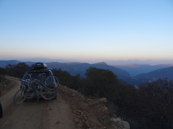
After the hike we continued north on the Ruta Sierra Juarez and and back to the main road (Ruta 175). After a cold night of camping just off the road, we decided to cross the mountains directly west to get to Ruta 135 on the other side. At the turnoff to the small road to cross the mountains, we came to a gate with a guard. We told him where we wanted to go and he told us we should return to Oaxaca to reach Ruta 135 since it would be much faster. After explaining that we wanted to drive through the mountains and explore the small towns along the way, and that we understood it would be a much longer drive, he recorded our names and license plate number in his log book and opened the gate for us. We never discovered why the road was gated or why the guard recorded our information but we suspected it could be to minimize illegal timber harvest and\or drug trafficking in the remote area.
The dirt road was very curvy and steep but generally in good shape. And the views around us were spectacular. For the first hour, we passed through dry scrub dotted with cactus. As we dropped down into the first valley, we crossed a wide, shallow river. We parked and jumped into the cool water. The only creature around was a cow who watched us soak. Ha! After a few more hours of driving, we came to the small town of Abejones (population ~1,100). People were busy preparing for Semana Santa festivities, putting purple and white prayer flags and garlands with large white flowers made of palm leaves around the central plaza and across the narrow roads through town. We parked to visit the church, saying hello to the group of men standing outside staring at us. They likely didn’t get many foreigners there, or at least many driving into town on their own (and not part of a tour). As we continued through town, we came upon a group of people in the street who were hanging a large garland across the road. It took them some time to figure out how to move the garland out of the street without disrupting it. We thanked them warmly as we passed, hoping our smiles would make up for disrupting their work. After driving a few more blocks, we came to another group of people hanging another garland. After a shorter wait this time, they moved the garland out of the street so we could pass. After all that, I took a wrong turn, looped through the town again, and ending up back on the same street where the same people were hanging the garlands. As they moved the garlands, again, two men came over to ask where we were trying to go, likely to help us find our way but perhaps to also ensure we didn’t bother them a third time. We told them our route and apologized for bothering them again. They pointed us in the right direction and wished us safe travels. Hopefully they had a good laugh at the silly tourists.
As we continued through the mountains and into pine forest, we passed the largest century plant I’d ever seen. I had to take a picture! As I got out of the truck, I immediately heard a loud hissing sound. Crap. We had a hole in the tire. Since the tire changing tools are stored under the back seats, we had to remove almost everything from the back of the truck to get to them. On the plus side, I found my missing sunglasses! Tools in hand, Mathieu started to loosen the lug nuts. Two of the nuts didn’t budge, even under his full body weight. Changing a tire is not hard or stressful. But when you can’t get the tire off and you’re ~20 mi (33 km) from any town and you hadn’t seen another car all day, it becomes stressful. We took some deep breaths, ate lunch, then returned to the task. Thankfully after many more tries, the lug nuts loosened, we changed the tire, repacked the truck, I took a picture of the century plant, and got going again. We continued the drive through the beautiful mountains and valleys, going through the small town of San Miguel Aloapam (population ~2,600), then on to Altayuca, the bigger town in the area.
In Altayuca, we stopped at a small store for a snack. As I pulled away from the curb, I realized I had no brakes. I had to stand on the brake pedal with all my weight and crank the hand brake as high as it would go in order to stop. I came within an inch of bumping into the truck parked in front of us. The owner of the truck I almost bumped into told us it was common for people’s brakes to be hot and nonfunctional after driving down the road we’d been on. Hmm…that was comforting. After a nerve-racking, super slow drive through town, the brakes cooled and were again functional, and we could breath again.
We continued north on the highway (Ruta 135), stopping to have the flat tire repaired, then took a secondary road east to Santiago Apoala, a tiny town (population ~800) along the Ruta Mixteca, another ecotourism route known for its natural beauty and recreational opportunities. The hills were smaller and covered with small trees and shrubs. The soil in some areas was a beautiful dark red. It was cool to be in a landscape so different then where we’d spent most of the day. We found a wild camping spot just off the road above Santiago Apoala and with cold beers in hand, we enjoyed the sunset and thanked our lucky stars that, despite our tire and brake troubles, we’d made it there.
In the morning, we woke to see the fog slowly pouring over the sheer, rocky cliffs on the opposite side of the valley. It was lovely. At the tourist office in the small town, we hired a guide, Rosa, a 15-year old who’d been working as a guide for 1.5 years. She lead us to a nearby cave used in prehistoric times for prayer and human sacrifice, then up a deep canyon to see pictographs representing the moon, the sun, and a millipede. After, we hiked down a steep trail to a small waterfall and swam in the refreshingly cold pool below the fall. It was not really necessary to have a guide given that all three attractions were close to the town center and one could easily follow the trail of tourists (domestic) to get there. However, Rosa was super sweet and it was great to spend a few hours with her and learn more about the community and the area.
After a lunch of more delicious mole, we continued north on small secondary roads to loop back to Ruta 135. During the 2-hour drive, we crossed several beautiful valleys, passed only one tiny village surrounded by rocky farmland, and saw no other vehicles. Coming out of the mountains and now on the main road, we followed a wide river where people were escaping the heat and swimming in the cool water. With the lush vegetation along the river, it was like a long, snaking oasis in the otherwise dry, brown landscape.
As we continued north, crossing into the state of Puebla, we passed a sign for the Reserva de la Biosfera Tehuacán-Cuicatlán. The reserve was not mentioned in our guidebook or on iOverlander but per the pictures on the sign, it looked beautiful and it was home to the world’s largest population of the military macaw, a large green parrot inhabiting the deep canyon within the reserve. The gate across the entry road was closed but not locked and since there was no sign indicating that entry was prohibited, we opened the gate and let ourselves in. We parked next to a handful of other cars then walked to the top of the steep stairs where we found a camping area with a few rustic cabins, picnic tables, and bathrooms. We said hello to the handful of people camping there, read about the hiking trails on the information kiosk, and went for a hike.
As we hiked up the steep path, we went through a forest of huge columnar cactus and other desert-adapted trees and shrubs. Per Wikipedia, the Reserve has one of the highest concentrations of columnar cacti in the world, which, along with its multitude of endemic and rare flora and fauna, is the reason it’s an IUCN-designated world biodiversity hotspot. There were only a few places along the hike where we could glimpse the deep canyon we were hiking along. Finally, at the end of the trail, we stood on the rocky cliff edge and got to see the 800-ft (240-m) deep Sabino Canyon and the landscape beyond. It was spectacular. We joined a handful of other hikers (domestic) and waited for the nightly return of the military macaws to their cliffside nests and roosting sites. Suddenly the quiet canyon was filled with the squawks of several pairs of parrots flying below us. They were flashes of bright green against the backdrop of the dark canyon. We watched them as they perched on small trees and ledges along the canyon walls; they never stopped squawking. After sunset, we hiked back to the truck. Back at the camping area, we were greeted by a park guard who informed us that access to the Reserve was by reservation only through the park office in the nearby town, and that a guide was required to hike and camp there. Oops. Thankfully, Mathieu is a gifted negotiator and despite the campground being full, the guard allowed us to camp for the night next to a small creek near the parking lot.
The next morning, we packed then hiked back through the cactus forest to the top of the canyon where we watched several pairs of the beautiful parrots as they left to forage for the day. The view of the canyon and surrounding area in the morning light was just as beautiful as it had been the evening before and this time, we had the viewing area to ourselves. While the guard hadn’t specifically said we could not hike in the Reserve (since we didn’t have a reservation or a guide), it seemed very likely that he’d be angry seeing us on the trail again. So after enjoying the view and the parrots, we quickly hiked back to the truck and got on the road again. Visiting the Reserve had been a very lucky, unplanned stop.
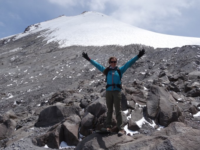
From the Reserve, we continued north on Rutas 135 and 144 to the city of Ciudad Serdan then northeast on secondary roads to Parque Nacional Pico de Orizaba (in the state of Puebla) where we would hike up our last volcano in Mexico. Per Wikipedia, the Pico de Orizaba volcano is the highest mountain in Mexico at 18,491 ft (5636 m) and the third highest mountain in North America (after Denali in the US and Mount Logan in Canada). The volcano is dormant but not extinct and is home to the highest glacier, Gran Glacier Norte, of the three volcanoes in Mexico that continue to support glaciers. Needless to say, I could hardly contain myself as we drove closer to the massive, snow-covered volcano. We’d saved the best for last.
After a cold night wild camping on the side of the dirt road leading up the volcano, we drove to the road’s end at Refugio Piedra Grande, a basic shelter at 14,022 ft (4274 m) where mountain climbers and hikers could sleep before and/or after their summit hike. After a quick hello to the handful of hikers staying at the refugio, we put on our daypacks and started up the trail. We could immediately feel the effects of being at high altitude. We continued slowly up the trail, stopping as needed to fill our lungs with more air. Apparently, the early explorers of this peak were not fans of zig-zagging because the trail literally went straight up from the refugio to the peak. Sheesh. The temperature was cool but it was a sunny, cloudless day and the the views of the snow-covered peak in front of us and of the valleys around us were spectacular. About halfway up, we crossed a group of hikers on their way down. They’d left the refugio at 2am to summit. They’d had a great hike, saying that while there was not a lot of snow, the trail to the peak was very steep and slippery, making crampons necessary. Of the group of five, only one person summited, the others being too exhausted to continue. “La proxima vez” (next time), they said. As we continued up, the number and size of the patches of snow and ice increased. At just over 16,000 ft (4900 m) Mathieu decided he’d gone far enough. Me though, I had to at least get to the edge of the glacier which was about 500 ft (150 m) further up the steep trail. After another 30 minutes, I was finally at the glacier’s edge. I sat on a rock and marveled at the scenery around me and at the peak still above me. I was very happy to be there but it was a little frustrating to be so close to the peak and unable to reach it. I considered trying to summit but knew it’d be unwise since I wasn’t prepared (e.g., no crampons and insufficient water and food) and Mathieu would have to wait some hours for me. “La proxima vez”, I told myself. After enjoying the view from 16,598 ft (5059 m), I returned to Mathieu and we climbed down the steep trail, arriving to the truck at 4:30pm. Our short 3.3-mi ( 5.3-km) trek had taken us 5 hours! But we’d gained and loss 2,694 ft (821 m) of elevation in that short distance and climbed to a height of over 16,000 ft. Wow. It’d been a breathtaking day, literally and figuratively.
After the hike, we drove back down the volcano and west on Ruta 150. After a few hours, we neared the large city of Puebla. By now it had started to rain hard and we were stuck in post-Semana Santa holiday, Sunday night traffic. After some searching, we found an auto hotel for the night. We showered, cooked dinner in the room on our camp stove, and toasted our exhilarating day with some red wine. Later, we collapsed in bed to watch TV. This time there were three TV channels. In addition to the porn channel found in the other cheap, roadside auto hotels we’d stayed in, we also had a local news channel and a movie channel. Perfect! That night’s movie was El Pecado de Adan y Eva (The Sin of Adam and Eve), which per Wikipedia, is a Mexican biblical epic film from 1969. What better way to end an amazing day on Mexico’s highest peak than by eating a delicious burger, drinking delicious wine, and watching a deliciously cheesy “biblical epic” in a cheap roadside auto hotel. Ha!
We had a great time continuing our travels through the interior of the state of Oaxaca and revisiting new areas in the state of Puebla, exploring mountains and interesting towns, viewing beautiful wildlife, and meeting new people. During this 9-day section of the road trip, we drove roughly 620 mi (1,000 km). We camped 6 nights (3 nights wild-camping and 3 nights in paid campgrounds, the most expensive being 120 pesos, ~$7) and stayed in hotels 3 nights (the most expensive being 340 pesos, ~$19). We felt safe the entire time.
And the road trip through Mexico with my wonderful trip partner Mathieu continues…stay tuned for upcoming posts!
Here are a few pictures. Click the link to see the full album: https://photos.app.goo.gl/nMH3P2SfPp4NXCPt2
Enjoy!
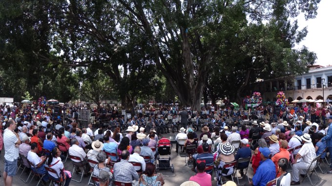
Beautiful music in Oaxaca.
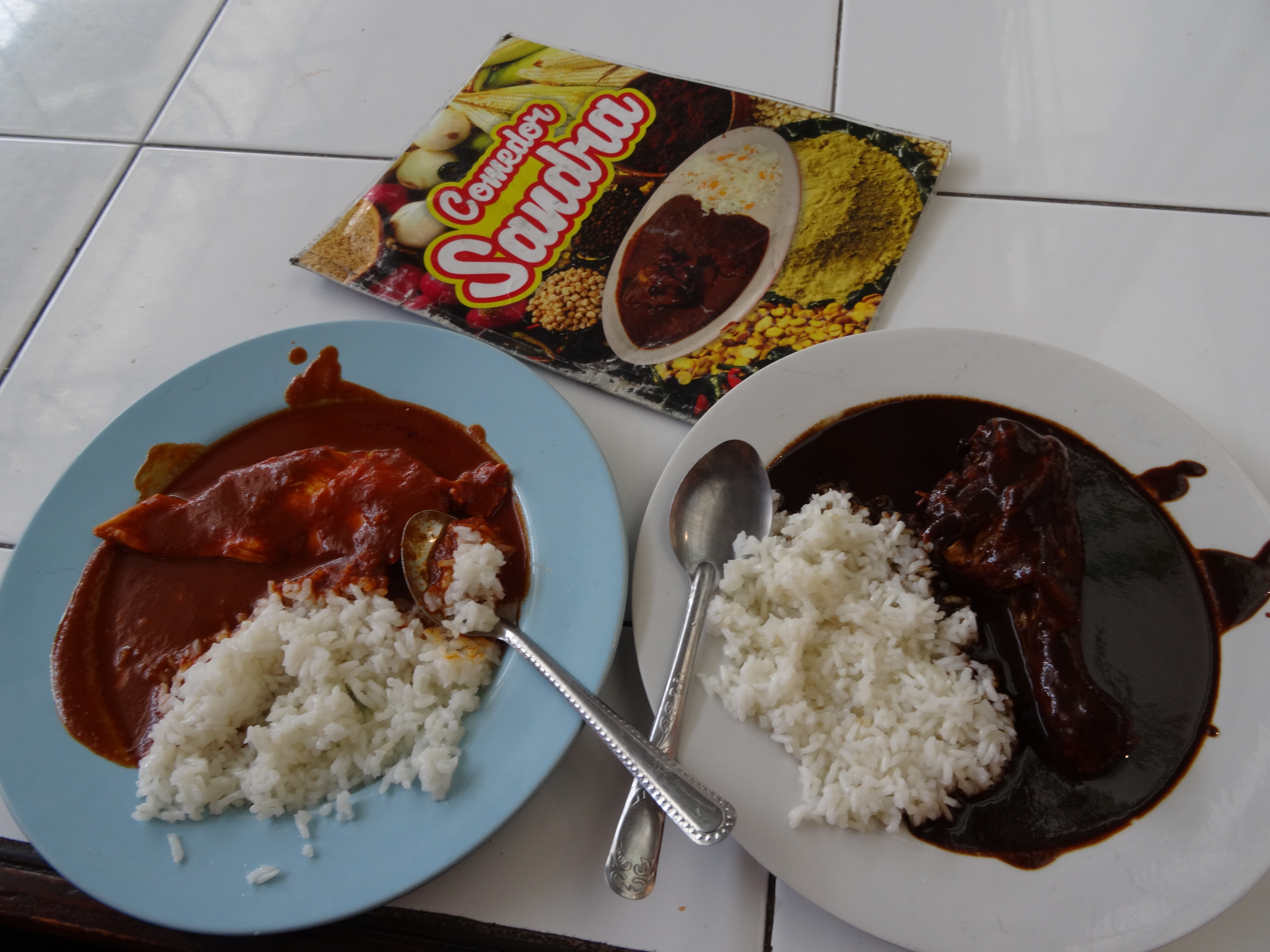
Mole! 
No more mole!
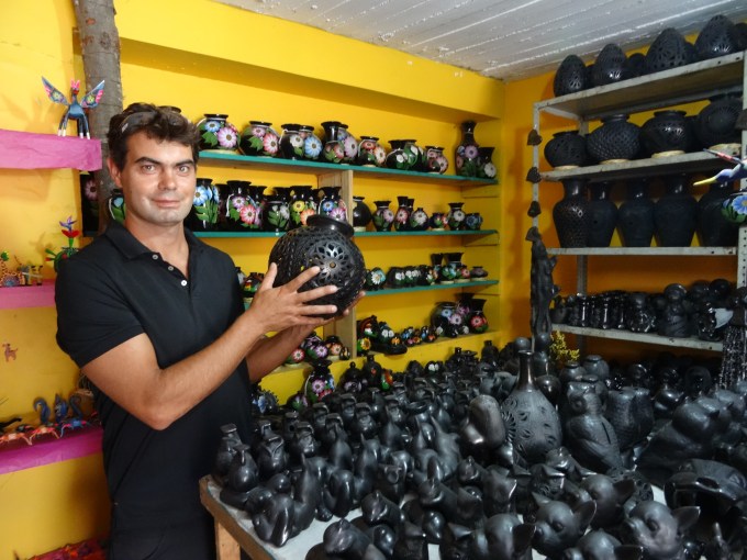
Traditional barro negro pottery in San Bartolo Coyotepec.

Traditional alebrijes in San Martin Tilcajete.

Morning light on the natural pool at Hierve el Agua.

Overlooking the petrified falls at Hierve el Agua.
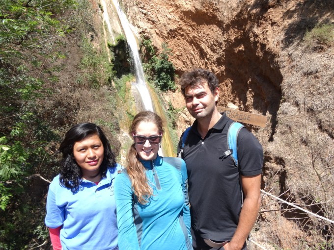
Our young guide, Rosa, who toured us around Santiago Apoala.

Hiking in the columnar catcus forest at Reserva de la Biosfera Tehuacán-Cuicatlán.

Overlooking 800-ft (240-m) deep Sabino Canyon at Reserva de la Biosfera Tehuacán-Cuicatlán.
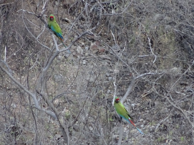
Military macaws at Reserva de la Biosfera Tehuacán-Cuicatlán.

Approaching Mexico’s highest peak, 18,491-ft (5636-m) Pico Orizaba.

On our way up Pico Orizaba.
At the foot of the Gran Glacier Norte on Pico Orizaba.

Just finished your latest wonderful post from Mexico. Am hungry foe mole and your next chapter! I think you are now in France and hope everything is going well for you. Belated happy birthday! Love, Aunt Pat
LikeLike
Thanks for reading it aunt Pat. I always appreciate your comments: ) The next chapter is coming soon. I hope to see you and uncle Dave soon. xoxo
LikeLike