
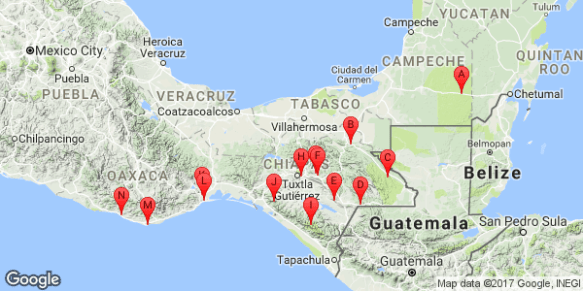
After 15 days traveling through the Yucatan Peninsula (see previous post), Mathieu and I continued our road trip through Mexico, spending the next 18 days in the states of Campeche, Chiapas, and Oaxaca.
Click HERE to go directly to the full photo album or click “Continue reading” to read more about our road trip adventure through this part of Mexico!
From Bacalar, we drove west on Ruta 186 through the state of Campeche. While looking at iOverlander for places to camp for the night, we read a description of a “bat show” that occured nightly at Volcan de los Murciélagos (volcano of the bats). It was almost sunset and the cave was on our way. Perfect! The bat cave, located in the Reserva de la Biosfera Calakmul, was accessible via a short, paved path. We joined a dozen other tourists (locals and foreigners) waiting for the show to begin. At about 7pm, the bats started to emerge from the cave entrance and fly up the steep-sided pit and into the night to forage. The show started with a few dozen bats then swelled to thousands. We could feel the wind they created as they spiraled up. We stayed until almost dark, continuing to watch as the last bats trickled out. After the show, we found a spot along an access road a few miles down the highway to wild camp for the night. We read later on Zocalo.com.mx that the cave is home to an estimated 2.3 million bats consisting of eight different species, and that it is very rare that so many species live together. We were so lucky to have seen such an awesome display.
The next day, we continued driving west then south on Rutas 203 and Ruta 307, crossing into the state of Chiapas. Once on Ruta 307, we paralleled the Guatemala border. We’d read about beautiful rivers and waterfalls in the nature reserves along this road. The first waterfall we visited was Cascada Las Golondrinas, a set of three waterfalls owned and maintained by the local community. While not very high, the clear, turquoise-blue water surrounded by thick lush green vegetation was beautiful. We arrived just in time to watch the golondrinas (swallows) begin the nightly return to their nests which hung on the rock wall behind the waterfall. As they flew by, they seemed to disappear into the falling water. Other than a group of people picnicking nearby, we had the waterfalls to ourselves. After swimming and waterplay, the very nice caretaker allowed us to set up our tent in the parking lot. While chatting with him, he pointed out an animal moving very slowly high in the trees above us. It was a perezoso, a tree sloth. So cool.
The next morning, we walked up the paved path to visit the falls again, spending the day swimming, journaling, and enjoying the beauty and solitude (we had the place entirely to ourselves). From there, we continued south on Ruta 307, paralleling the Reserva de la Biosfera Montes Azules and Monumento Natural Bonampak. At this point, we were about 1 mi (2 km) from the Guatemala border so could see the thick jungle and high mountains on the other side. It was amazing. While driving on the secondary road through the Reserva de la Biosfera Lacantun, we saw a pair of red macaw parrots fly overhead followed by a pair of small green parrots. In hopes of seeing more parrots, we wild camped that night on the banks of the Rio Lacantun, near the small town of Reforma Agraria. Along with seeing a few more pairs of parrots fly overhead, we were serenaded that night and the next morning by howler monkeys, various birds and insects, and toads in the thick forests around us.
After a quick wash for Genevieve (my 4Runner) and ourselves in the river, we continued on the secondary road to rejoin Ruta 307, passing through thick forest, large cattle ranches, and several very small towns, and crossing beautiful blue rivers a few times along the way. Our destination that day was Las Nubes, a centro ecoturistico we’d read about on iOverlander. It was a resort known for its beautiful waterfalls along the Rio Santo Domingo. We set up camp in a grassy field at the resort then went hiking. The trail took us first to “The Tunnel” where the river thundered through a large hole in the rock. We then hiked the steep path to the mirador (overlook). The view was stunning. At this point, the wide, crystal-clear turquoise-colored river branched, becoming large ribbons of blue streaming over the landscape. Wow. It was wonderful to be in such a beautiful place, especially since we had it almost to ourselves.
After deciding to stay another night, we spent the next day relaxing by the river, reading, journaling, napping, and swimming. Later, we hiked back to The Tunnel so Mathieu could fly the drone along the river and video the water crashing through the hole. However, shortly after take off, the drone lost connection with the remote control, likely due to the strong water spray, and crashed. Crap. Fortunately we were able to retrieve it. Unfortunately, it crashed into the water and was completely submerged. Mathieu took it apart and put it in the bag of rice to let it dry alongside the now non-functioning GoPro. (This trip had been rough on the electronic toys). Our fingers were crossed that both would recover.
From there, we continued on Ruta 307 to Parque Nacional Lagunas de Montebello where we hiked around a huge, stunningly blue lake surrounded by small, steep mountains thick with lush vegetation. The various flowers along the way were gorgeous and included a few varieties of brightly colored orchids. After the lake, we explored the Grutas San Rafael El Arco, a group of medium-sized, shallow caves with huge formations. Per the flowers, candles, and some beer cans left in the largest caves, they appeared to be used by locals as places for prayer and party. After visiting the national park, we continued west on Ruta 307 then on Ruta 226, a secondary road, to Cascadas El Chiflón, a centro ecoturístico, containing five high waterfalls. The entry to the site was closed when we arrived after 6pm so we set up camp at a nearby picnic area to wait until the morning.
After a dip in the small river next to our camp, we drove back to the falls. This centro ecoturístico was very developed with a hotel, food stands, restaurants, souvenir shops, riverside picnic areas, and several ziplines for a bird’s eye view of the river and falls. However, since it was a weekday, it wasn’t crowded. We walked up the steep, paved trail taking us to each of the five waterfalls: Cascadas El Suspiro (82 ft; 5m), Ala de Ángel (98 ft; 30 m), Velo de Novia (394 ft; 120 m), Arcoiris (174 ft; 53 m), and Quinceanera (197 ft; 60 m). All of the falls were awesome but of course the tallest waterfall, the 394-foot Velo de Novia, was really awesome. Similar to the other falls we’d visited, the water was crystal-clear and turquoise blue, and the cream-colored clay bottom accentuated the beautiful water color even more. After our hike, we found a nice picnic site along the river and spent the day swimming, journaling, and relaxing.
At closing time, we were ushered out and continued north on Ruta 226 toward San Cristóbal de las Casas. After a few hours, we came to a halt behind a long line of stopped cars. After asking around, we found out there was a protest. Apparently, the protesters would periodically let about 50 cars through then block the road again. The other drivers appeared to be used to it, all pulling up to the line and immediately cutting their engines. We weren’t sure how long we’d have to wait but the only other option was to return the way we came and go the very long way around. We decided to wait. While waiting, Mathieu read outloud about the politics and socioeconomics in the state of Chiapas, translating for me from his Mexico guidebook written in French. Per the guidebook, Chiapas is the poorest state in Mexico but the richest in terms of natural resources, and is home to the Zapatistas, made up of mostly rural indigenous people. Named after revolutionary Mexican leader Emiliano Zapata, the Zapatista ideology blends Mayan tradition with socialism, anarchism, and Marxism. The group primarily seeks indigenous control over their local resources, especially land. Based on the protest, it appeared that the indigenous population still does not enjoy equal rights and the struggle continues. After almost 1.5 hours, the long line of vehicles started moving. As we proceeded through the tiny town, we passed many people standing along the road but it was difficult to discern who the protesters were. We finally arrived to San Cristóbal around 9pm and went directly to our hostel.
Per Wikipedi, San Cristóbal de las Casas, a Pueblo Mágico known for its colonial architecture, is considered the cultural capital of the state. Much of this culture is associated with the city’s large indigenous population, mostly made up of Tzotzils and Tzeltals most widely known for making textiles. We could see immediately that it was a charming city, with a laid back, artsy vibe. Despite its charm, we spent the entire next day in our comfortable room journaling, reading, and watching videos with the strong wifi. After many days of camping, it felt great to just chill indoors. Plus it turned into a rainy day, adding credence to our decision. Mathieu also spent time trying to fix his waterlogged drone. Using parts from his other drone (crashed in Anza Borrego State Park in California), he got the drone flying again but the camera still didn’t work. A local shop tried but was unable to fix it so he’d have to get a new camera when back in France. At least now the drone would fly again in the future.
After our day of sloth, we spent the next day exploring the area via bicycle. Our bikes were pretty beaten up after so many miles on the back of the truck but despite the rusty chain, mine still worked, only skipping occasionally. We rode our bikes through the streets of San Cristóbal, then on a dirt path through the forest and through a few small villages and to the small neighboring town of San Juan Chamula which, per Wikipedia, is almost entirely inhabited by Tzotzil people. It was great to see the interesting traditional clothes worn by the indigenous people of the area. The women wore black sheepskin skirts held around their waists by cotton belts, colorful blouses, shawls, and often wore colorful headscarves. The little girls were especially adorable in their colorful outfits. Some of the men wool ponchos over white shirts, and black pants with colorful cotton belts. It seemed too warm outside to be wearing such heavy clothing but obviously they were used to it. We called out hello as we passed and were offered shy smiles and hellos in return.
Once in Chamula, we went to the town’s central plaza. As usual, there was a beautiful church serving as the focal point of the plaza. Unlike others we’d seen so far, the church of San Juan was painted bright white with blue trim and beautiful, colorful designs around the doorway and on the front. While in the plaza, I was persuaded (easily) by a tiny, ancient-looking local woman to buy some of her handmade goods: two small, brightly-colored purses and a pair of small dolls made of local sheep’s wool. The colors were so vibrant and would be wonderful reminders of this area of Chiapas (and of the tiny woman who made them). From the plaza, we walked slowly along the side streets, lined with shops and stands all selling local, handmade goods (i.e., purses, animal figurines, dolls, clothes, tapestries, etc…) then had lunch at the market: chicken mole with fresh tortillas. I always loved eating at the markets. Besides the usually delicious, cheap food, it was a great place to get a glimpse of the locals’ daily lives.
The next morning, we prepared to explore San Cristóbal more. However, when I went to the truck, I noticed something was amiss. The side window was busted; we’d been robbed. The thieves took the cooler, a large plastic bin containing the camp stove, cooking stuff (i.e., pot, pan, plates, bowls, cups, utensils, etc…), and two bags of food, mostly canned and dried foods. More importantly, they took the bag containing the remote control, batteries, and charger for the drone which, along with the expense of these items, was particularly frustrating after the time Mathieu had spent two days before to get it flying again. Crap.
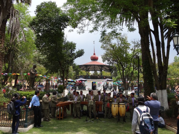
It was a bummer way to start the day but while frustrating, they could have taken many more items left in the truck. The police arrived within an hour and we described to them, all four of them, what was stolen. Then two motorcycle police escorted us to the station where we made an official report. We didn’t expect to get our things back but thought it could be helpful to report the theft anyway. The officers were all very friendly during the 2+ hours we were at the station. When we returned to the hostel, the owner, who’d helped us throughout the day, let us park Genevieve in the gated yard of his house nearby. After relaxing for a bit, we decided to make the best of the remainder of the day, so explored the city. And thank goodness we did because there was a fiesta going on downtown. There were dozens of people in the plaza gathered around a large orchestra lead by a very animated conductor. They sounded great. The trees in the plaza were decorated with streamers, fresh flowers and wreaths, and lights, as were the buildings and the church surrounding the plaza. It was wonderfully festive. Later, Mathieu took me to dinner at a quaint cafe where we sat on a small balcony sipping wine and eating delicious food while watching the people and various street performers below. It was a wonderful way to erase the frustrations of the day.
The next morning, we returned to the town center where the fiesta was ongoing. We enjoyed the music of a live band and the festive vibe of the plaza for awhile then went to an artisanal market to explore the large labyrinth of stalls of local merchants selling their handmade goods. It was fun to check out all the colorful clothing, tapestries, dolls, purses, jewelry, pottery, etc… After buying some beautiful tapestries and pottery, we left San Cristóbal, driving west on Ruta 190 to Chiapa de Corzo. As we drove down the curvy road and into the valley, the temperature increased exponentially. It was shocking how much warmer it was. We’d planned to camp that night but it was too hot to sleep in a tent. After some searching in Chiapa de Corzo, we finally found a reasonably priced hotel with secure parking (now a requirement) but our room did not have AC. While the two fans helped some, they mostly just moved the hot air around. We spent the evening lying in front of the fans, continuously misting ourselves with a spray bottle, neither of us wanting to admit we should have sprung for the more expensive room with AC.
Despite a restless night of sleep, we were excited the next morning to visit Parque Nacional Cañón del Sumidero where we would take a boat tour through the steep-walled canyon cut by the Rio Grijalva. We waited for about an hour for the small tour boat (one of dozens) to fill up with tourists then finally started the drive upriver and into the deep canyon. We spent nearly 2.5 hours touring through the awesome canyon during which we saw monkeys in the trees, black vultures sunning on the shore, and a huge crocodile along the river bank. Immediately after getting off the boat, we drove to the top of the canyon, stopping at each of the six miradors overlooking the deep canyon at various points. Per our guidebook, this was the 2nd most popular attraction in Chiapas after the Mayan ruins of Palenque and now we knew why.
After a night of wild camping a few hours south of the canon, we continued along Ruta 28, a secondary road, to the Reserva de la Biosfera Triunfo located in the Sierra Madre mountains in the southern part of the state. We’d read in our guidebook and had been told by the guys at a local PEMEX gas station that we needed permission prior to entering the Reserve. So, we spent several frustrating hours being redirected to different addresses of “the office” until finally being told by a police officer that we didn’t need permission. While we weren’t 100% certain he was correct, we went with it. We liked his answer best, and after all he was a person of authority.
As we continued south to the Reserve, the mountains became higher and the valleys deeper. It was beautiful. We passed through only a few very small towns. Without a doubt, we were the only tourists in the area. We had to use our two mapping apps (Maps.me and Google maps), our paper road maps, and directions from locals in order to figure out where we were and how to get to where we wanted to go. After several more hours of driving on small roads, we entered the Reserve. There was no sign marking the boundary; we only knew based on Google maps (Maps.me didn’t show the Reserve at all).
We followed the road south into the Reserve, going up and down the small mountains and through the forest. At the end, we drove through the ejido (village) of Tulcan then up a hill, ending at a small plaza where there was a basketball game in progress. The players parted to let us pass through then resumed as soon as we parked. The few people, mostly older men, on the sidelines chatting and watching the game, stared at us with curiosity but responded kindly when we said hello. We walked up the only street leading from the plaza not knowing where we were going. After passing a few houses, we asked a woman about the hiking trails in the area. She explained that there were many, most of which were used by locals to travel to neighboring villages. We then asked if there was someone who could take us hiking, a guide. This was not a touristy place and this didn’t seem like a typical request. As we chatted, an ancient-looking woman joined our group. After explaining to her that we wanted to hire a guide, she lead us back to the plaza, where the basketball players were now resting. She told the group of our request. There were many laughs. No one wanted to climb the mountain, even if paid. Finally after a few phone calls, Nicanor Robaro Soliz arrived, saying he would take us hiking. He was very friendly, as was everyone, and also got permission for us to camp on his neighbor’s property along the river.
Once our tent was set up, we enjoyed the scenery around us. Our campsite was visible to a few of the houses on the opposite hill and to those on the slope above us. We were the excitement for the evening and caught people standing in their yards watching us. As we relaxed at our campsite that evening, we were visited by a few curious locals. Upon hearing we’d be hiking the next day, they told us more about the area and the animals we might see (i.e., jaguar and tapir). It was fun to chat with them.
The next morning, Nicanor arrived at 6am. Sometime during the night, I’d been hit with what felt like mild food or water poisoning but I was determined to hike. We hiked up a well-worn path along the river with our machete-wielding guide enjoying the sounds of various birds and insects calling out in the forest. Nicanor was a wealth of information about the area and life in the community, and thankfully didn’t mind us peppering him with questions. During the hike, we passed a few other locals herding cows along the river and passed by some small coffee farms. After about 3 hours of hiking along the narrow path through the thick forest, we reached the turnaround point but Mathieu and I, despite me feeling a bit weak, wanted to hike further up the mountain. So we said farewell to Nicanor and continued. As he left, he reassured us that while the narcos (drug traffickers) transported cocaine across these mountains, they used trails much further away so we’d be safe to hike alone. Hmmmm…We hiked another 1.5 hours then reached a saddle where we could see a town on the other side and possible glimpses of the Pacific Ocean. I tried to enjoy the view and forget how bad I was feeling, now hot with mild fever and nauseous. The return hike seemed to me to last an eternity, especially since the sun was high by now and it was hot outside. Back at camp, I soaked in the cool river and once I felt a bit better, we packed up, and left, me deciding I needed a hotel with AC for the night.
After a few hours on the bumpy, curvy road from which we’d come, Mathieu noticed that the bikes were moving more than usual on the rack. He got out to check and called out, “we have trouble.” The pin holding the bike rack upright had bent and no longer went all the way through. If we kept driving with it in this condition we risked the pin coming out and the rack crashing to the ground and dragging the bikes. Crap. All I wanted was to get to a hotel! Fortunately we were near a small town and were directed to a nearby mechanic. And thankfully, Mathieu knew the words in Spanish to get the rack fixed which required enlarging the pin hole to insert a new screw that the mechanic found laying around the garage, and welding the rack’s seams.
With the bike rack fixed, we continued the drive, searching for a hotel with AC. The first hotel we encountered was a dump with non-functioning AC units. So we drove on. The second one was slightly less of a dump but while the AC units technically worked, they emitted only a wisp of cool air. After testing the AC units in three different rooms, the manager assured us that the room would be cool after the unit ran for about an hour. I was so frustrated by now that I could have screamed and cried (or visa versa). It was 8pm, still hot, and I still didn’t feel well. We went to the town center to find some food while the room cooled. When we returned, the room was only slightly cooler but a cold shower helped me to cool off (literally and figuratively). I was glad to have hiked with Nicanor in the beautiful mountains of the Reserve but now I just wanted to sleep and for the day to be over.
I felt much better the next morning. Refreshed and re-energized, we drove south. Thinking it would be more scenic (and shorter) to drive through the Sierra Madre mountains and along the Reserva de la Biosfera La Sepultura, we took a secondary road instead of the highway to get to the Pacific coast. The dirt road was fine overall but pitted in many places so the scenic drive was slow. After about 25 mi (40 km), we came to the tiny ejido of Sierra Morena where we were stopped by a chain strung across the road. WTF? Why was there a chain across the public road? Asking a woman nearby, we were told we had to find the person with the key who lived across from the clinic. After some searching, we found the super friendly guardian of the key. The woman explained that the area was an ecotourism site and told us that for a small fee, we could use the hiking trails and visit the mirador. We explained that we only wanted to get to Tonala, the coastal town on the other side of the mountains. She happily gave us the key, we unlocked the chain, relocked it behind us, returned the key to her and were on our way. We continued wondering how they could close a public road. Then after about 20 minutes we came to the mirador, and the end of the road. The road just ended at a cliff! The view of the valley below and the ocean in the distance was lovely but now we’d have to return the way we came. Crap. Now we understood why the road had been closed.
As we drove back to the chain gate, we wondered why the woman hadn’t told us that the road did NOT go to Tonala. The key guardian seemed surprised that we were back so soon. After we made the obvious statement that the road ended and did NOT continue to Tonala, she told us it had been destroyed in the 1998 hurricane and never repaired. We told her that our paper map was incorrect since it showed the road still going thru. She’d apparently thought we’d wanted to walk or mountain bike to Tonala. Ha! Once she understood that we’d wanted to drive there, we all laughed. She happily gave us the key, we unlocked the chain, relocked it behind us, returned the key to her then drove the 25 miles back to our starting point at Villa Flores. We laughed it off; it was all part of the adventure.
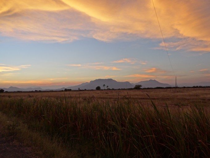
We continued our drive to the coast by going west on Ruta 190, a secondary road, then going south on Ruta 200, crossing into the state of Oaxaca. We’d decided to stop for the night in Tehuantepec. However, about 6 mi (10 km) from the city, we came to a halt behind a long line of stopped cars. It was another protest. Crap. From the gaps in the line of cars in front of us, it appeared that it’d been going on long enough for many people to have turned around. We waited for about 15 minutes then decided to try to wild camp nearby. We’d already been driving for 9 hours that day and were tired. We found a place to camp next to a farm field. We were out of sight of the road and the nearby ranch houses and had a beautiful view of the sun setting behind the mountains. While watching the changing colors of the sunset, we toasted another adventurous day.
The next morning we got back on Ruta 200 to Tehuantepec. We’d only driven a few miles when we again came to a halt behind a long line of stopped cars. The protest was ongoing. Crap. We immediately turned around and while on the side of the road consulting our various maps for an alternative route, a local in a pickup truck stopped to ask where we were going. We told him and he waved for us to follow him. He lead us north then west on an unmarked dirt road passing many ranches and small clusters of houses. At an intersection, he pointed us toward the main road. These roads were not on any of our maps (paper or electronic) so we were extremely grateful for his help.
After a few hours of winding through the mountains, the Pacific Ocean finally came into view. It looked so blue against the brown vegetation of the dry mountains. We drove to Bahia Bamba, a beautiful long, curved beach with white sand and mountainous sand dunes. Per our guidebook, it was a popular surf spot. Besides us, there were a handful of surfers in the water and a handful of local fisherman casting nets into the surf. It was so nice to be back at the ocean. And we saw whales! After a few hours of walking on the beach, swimming, and playing in the massive dunes, we continued west to the small town of San Agustin where we found a rustic campground on the beach. We spent the rest of the day swimming, chatting with our neighbors, and relaxing.
While enjoying the sunrise the next morning, we decided to stay there another night and spent the day swimming and journaling, reading, and napping under the palapa. Later we walked along the town’s only road. Given the many small restaurants, hotels, and shops, it was clear that this was a popular destination, likely bustling on the weekends but fortunately for us, very quiet during the week. We enjoyed some delicious quesadillas at the only restaurant open at 8pm on a Thursday night then walked back to camp under the light of the nearly full moon. It’d been a wonderful day relaxing in paradise.
We started the next morning snorkeling for about an hour at a small reef at the end of the beach then continued west on Ruta 200 to Puerto Angel, a Pueblo Mágico. We didn’t feel the magic in this touristy, somewhat rundown beach town so we continued along the coast to Puerto Escondido, a large city filled with big hotels, restaurants, etc…and an airport. It was a destination city where tourists came to enjoy its long, curved white-sand beach and surfable waves. While very touristy, it maintained some character. We took a walk on Playa Zicatela, a surf beach famous for its long pipeline waves. We then went to the south end of the beach and watched dozens of terns and pelicans circling and diving between the dozens of surfers catching waves near the rocky point. We’d hoped to camp on the beach but the only option was to stay at one of the tiny, crowded “campgrounds” which were nothing more than the sandy parking lots of the associated hotel or restaurant. Instead we drove further north and with the help of our map apps found a small road that ended at the ocean. We found a great spot to set up camp on the long, totally secluded beach and enjoyed a gorgeous sunset. It was a wonderful way to spend our last night at the Pacific Ocean.
We had a great time traveling through the states of Campeche, Chiapas, and Oaxaca, visiting beautiful waterfalls, rivers, lakes, and beaches, exploring mountains, forests, jungles,and interesting towns, viewing amazing wildlife, and meeting new people. During this 18-day section of the road trip, we drove ~1,320 mi (2124 km), traveling mostly on the free roads (longer but cheaper and often more interesting). We camped 12 nights (6 nights wild-camping and 6 nights in paid campgrounds, the most expensive being 100 pesos, ~$5) and stayed in hotels 6 nights (the most expensive being 300 pesos, ~$17). We felt safe the entire time.
And the road trip through Mexico with my wonderful trip partner Mathieu continues…stay tuned for upcoming posts!
Here are a few pictures. Click the link to see the full album: https://goo.gl/photos/dJbXfzAVtYk51EU9A
Enjoy!

Bat flight at Volcan de los Murciélagos.

Waterplay at Cascada Las Golondrinas.

Our campsite on Rio Lacantun.
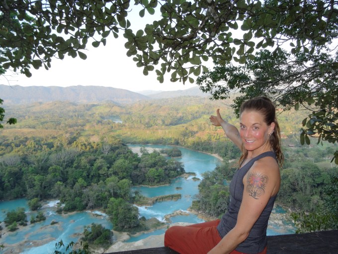
View of Rio Santo Domingo from the Mirador at Las Nubes.
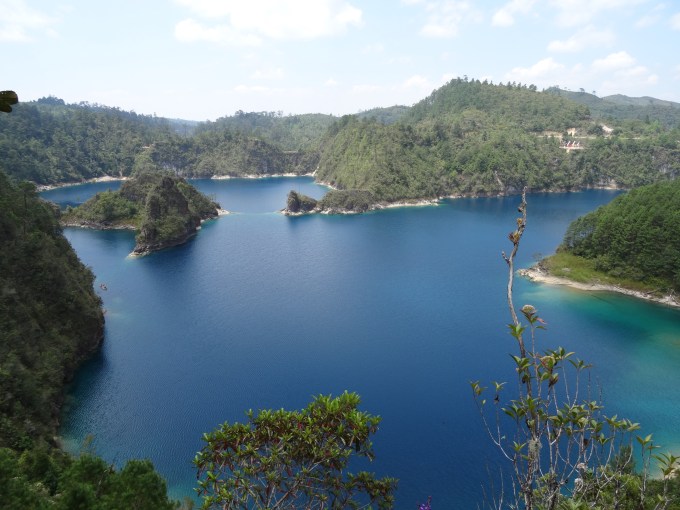
Parque Nacional Lagunas de Montebello

Church in San Juan Chamula.

Tzotzil women in San Juan Chamula.
Fiesta in the plaza in San Cristóbal de las Casas.

Shopping at the artisanal market in San Cristóbal de las Casas.

On a boat tour in Parque Nacional Cañón del Sumidero.

Hiking with our guide, Nicanor, in Reserva de la Biosfera Triunfo.

On the trail in the Reserva de la Biosfera Triunfo.
Sunset at our roadside camp near Tehuantepec.

Playing in the dunes at Bahia Bamba.

More playing in the dunes at Bahia Bamba.

Relaxing on the beach in San Agustin.

Sunset on a secluded beach west of Puerto Escondido. Farewell Pacific Ocean!
