After 14 days traveling inland to Campeche (see previous post), Mathieu and I continued our road trip through Mexico, spending 15 days on the Yucatan Peninsula in the states of Yucatan and Quintana Roo.
Click HERE to go directly to the full photo album or click “Continue reading” to read more about our road trip adventure through this part of Mexico!
From the coastal city of Campeche, we drove Ruta 180 crossing from the state of Campeche into the state of Yucatan to visit the ruins of Uxmal. Per Wikipedia, the ancient Maya city of Uxmal, a UNESCO World Heritage Site, is considered one of the most important archaeological sites of Maya culture, along with Palenque, Chichén Itzá, and Calakmul in Mexico, Caracol and Xunantunich in Belize, and Tikal in Guatemala. Its buildings are typical of the Puuc style, with smooth low walls that open on ornate sculpted figurines. We spent about 3 hours slowly touring the site, especially enjoying the largest of the structures, the Pyramid of the Magician with its unique rounded corners. We were among many other tourists (mostly foreign) but there was plenty of space for everyone to feel the history of the place.
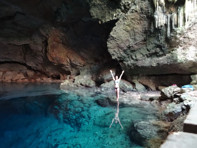
After visiting the ruins, we drove secondary roads through a bunch of very small towns (Santa Elena, Ticul, Chapab, Mama, Tekit, San Isidro Ochil, Cuzama and Homun). Many of the homes in these towns were very simple, often having palm frond roofs, and appearing to lack running water. However, most had beautiful green gardens filled with wild tropical flowers. There were almost no cars, and people got around on foot, bicycle, or small motorcycles. Based on the curious stares we got from every person we passed, it appeared that tourists didn’t frequent this route, making it even more interesting. We took this route to get to Cenote Oxola. The Yucatan Peninsula is known for its plethora of cenotes (natural sinkholes resulting from the collapse of the limestone ceiling exposing the groundwater underneath) and this would be our first of the trip. As described on iOverlander, the cenote was abandoned. It appeared that someone tried to make it a tourist attraction, building a stone wall around the sinkhole and building stairs to access the pool below, but perhaps it was too far off the beaten path to be successful. We arrived at night so had to wait until the morning to see the cenote. It was a wonderfully, secluded campsite with nothing around for at least several miles. After a night of stargazing, we woke up and climbed down the steep steps into the sinkhole to finally see the natural pool. Wow, it was amazing! We swam in the crystal clear waters and marveled at the formations both above and below the water. What an awesome place, and we had it entirely to ourselves!
After a morning of playing in the secluded cenote, we drove back to Ruta 180 and continued for ~1.5 hours to another cenote. The Yokdzonot Cenote is an ecotourist site run by a cooperative of Mayans from the village of Yokdzonot. It’s a 72-ft (22-m) deep sinkhole with a gorgeous blue pool that is so deep, over 115 ft (35 m) deep, that you can’t see the bottom. It’s a well known cenote but we shared the pool with only a dozen other tourists. We had a great time swimming along the formations at the pool’s edge and through the long tree roots extending down the sides of the sinkhole. And the cool freshwater felt wonderful. After the water play, we drove Ruta 180 to the small town of Piste and wild camped in an abandoned parking lot we’d read about on iOverlander (actually nicer than it sounds).
The next day, Mathieu rode his bike the short distance to Chichén Itzá, another of the important archaeological sites of Maya culture. I opted to relax at our campsite and catch up on my journal. After he returned from visiting the ruins, we drove Ruta 295 to Rio Lagartos, a small fishing town (population ~3,500) on the north coast of the Gulf of Mexico. We walked around the very quiet town for about an hour, enjoying the views of the small fishing boats and the mangrove-lined lagoon. After, we drove east on the long peninsula between the Gulf and the estuary, entering the Ría Lagartos Reserve Natural Park in hopes of seeing Caribbean flamingos (Phoenicopterus ruber). Per Wikipedia, the population in the Reserve is estimated from 4500 individuals in January to 26,000 in June. The light of the setting sun was gorgeous on the water, and illuminated the beautiful bright pink flamingos feeding in the giant lagoon. They were somewhat far from us but thanks to Mathieu’s drone, we got some great close-up video of them (perhaps a bit too close; oops). We watched the elegant creatures until almost dark then found a great camping spot on one of the man-made levees in the shallow lagoon. (Part of the lagoon is used for salt production.)
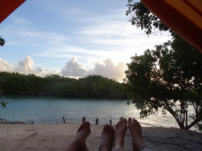
After a wonderful night wild camping under the stars, we woke to a lovely sunrise and more flamingos. We spent most of the day relaxing at our lagoon-side campsite reading and journaling (and drying out the truck after our 5-gallon water container emptied in the back). From there, we continued driving along the peninsula to the small fishing town of Cuyo then drove secondary roads back to Ruta 180, crossing into the state of Quintana Roo, and arriving to Cancun that evening. Neither of us were very excited to visit the super touristy city (population ~628,000) or its beaches but we were looking forward to visiting some of the surrounding areas. We stopped in town for some tacos then continued through the busy city directly to Punta Sam where we’d take the ferry the next day to visit Isla Mujeres. After getting info on ferry times, we found an abandoned parking lot nearby to wild camp. Again, it turned out to be nicer than it sounds, especially in the light of the nearly full moon.
The next morning, we took the short ferry ride to Isla Mujeres. This was our first stop at, and Mathieu’s first time seeing, the turquoise waters of the Caribbean. It was beautiful. Once on Isla Mujeres (population ~12,500), we spent the day riding our bikes around the 4.3-mi (7 km) long island. Per Wikipedia, the island was sacred to the Maya goddess of childbirth and medicine, Ixchel and when the Spanish arrived in the 16th century they named it “Isla Mujeres” because of the many images of goddesses. Since we arrived at about 9am, the hotel-, bar-, restaurant-lined streets of the Playa Norte area were mostly quiet. We immediately parked our bikes, ran across the white sand beach and jumped into the turquoise-colored ocean. It was lovely. After, we rode along the east side of the island, stopping along the way to enjoy the view of the ocean in this mostly structure-free area. We stopped to join the hordes of tourists, most of whom arrived via zippy rented golf carts, to admire the view from Punta Sur, at the southern tip of the island. From there, we rode along the west side of the island back to north beach, now bustling with activity. We enjoyed a delicious grilled fish lunch and cold beers at a beachfront restaurant then took the ferry back to the mainland. The island was very touristy but had a lazy, beach-town atmosphere and we had a great day bike riding along the beautiful coast. Back on the mainland, we drove to the Rio Nizuc Picnic Area. While not intended for overnight camping, we’d read on iOverlander that fellow travelers had overnighted there so thought we’d give it a try. It was a Friday night and there were several groups of locals hanging out at the small picnic area but we found a nice spot along the beautiful lagoon. It was funny to be camping, for free, in our 3-person tent within several miles of Cancun’s very fancy, multi-story beachfront hotels and resorts in the Zona Hotelera Ha!
From our waterfront “resort”, we drove to Isla Blanca, a long, narrow peninsula (not an island) with white sandy beaches between the Chacmuchuc Lagoon and the Caribbean only about 25 minutes north of Cancun. With its super shallow lagoon (no more than calf deep) and constant breeze, the area is popular among kitesurfers. Besides a few small kite surfing schools and a dozen private homes, the area is as yet undeveloped (but at least one huge hotel is on its way on the southern end). Mathieu hadn’t ridden his kite board since having a lesson in Los Barriles in Baja Sur so was happy to spend the day practicing. While he surfed, I spent the day journaling, reading, and watching the dozens of kites surfers zip across the lagoon. The site of all the colorful kites in the sky was cool to see. Since it’d been awhile since he set up his kite, Mathieu got help from our neighbors, Vanessa and Emiliano, experienced kiters on vacation from Argentina. We ended up spending the day with them, all of us hanging out when they weren’t on the water. At the end of the day, we said farewell to our new friends, watched the sun set over the lagoon then drove to a small spot we’d found where we could wild camp hidden in the dunes between two houses. It was an excellent way to spend our last day in Mexico before taking a 3-week trip to Cuba (stayed tuned for the upcoming post).
After returning from Cuba and running some errands in Cancun (including buying spicy peanuts, totopos, and other treats not available in Cuba), we returned to our secret beach spot on Isla Blanca where Mathieu kite surfed and I journaled and relaxed. It felt like a much-needed vacation after the whirlwind of traveling around Cuba. After three days at there, we spent a few nights at our resort spot at the Rio Nizuc Picnic Area, having a wifi day to reconnect with our peeps and the outside world, then continued south to explore more of the Yucatan Peninsula.
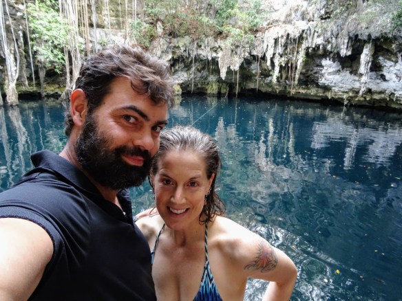
Leaving the Cancun area, we drove Ruta 307 to El Gran Cenote near the coastal city of Tulum. After several days camping on the beach and swimming in the saltwater lagoon, it felt amazing to swim in the crystal-clear, cool, freshwater cenote (and it was awesome to finally wash my hair in the showers there). The cenote is very popular for snorkeling and scuba diving and was crowded but once we moved to the edges of the pool, away from the safety rope down the middle, there were fewer people. The underwater formations were awesome! I could only imagine what it would be like to scuba dive into the depths of the cave. We had a great time snorkeling and trying to swim underneath and through the large formations.
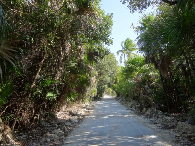
From the cenote, we continued south along Ruta 307 to Punta Allen, driving through the Reserva de la Biosfera Sian Ka`an. Per Wikipedia, part of the 2,039-sq mi (5,280-sq km) reserve is on land and part is in the Caribbean Sea, including a section of coral reef. The reserve is a UNESCO World Heritage Site and also includes 23 known archaeological sites of the Maya civilization. I’d spent two weeks in the Reserve in 1996 as part of my Coral Reef Ecology class while in graduate school (the world’s most amazing class trip). The road from Tulum to the entry to the Reserve was still a narrow, dirt road but it was now lined with boutique resorts, yoga retreats, restaurants, juice bars, veggie and raw food cafes, etc…While very touristy, it seemed like a nice place to hang out, having more of a hippy vibe then Cancun. There were a few small resorts along the dirt road in the Reserve but after several miles, they became sparse. As we continued further, the dirt road became more tunnel-like, lined on both sides by thick jungle. Beach access was limited either by the thick vegetation or by fences surrounding occasional lots of private property. During the occasional glimpses of the coast, we could see the white sand beach and the wind-chopped waves. Along the way, we passed signs warning of animal crossing: jaguar, white-nosed coati (a raccoon-like animal with a very long tail), iguanas, snakes, etc… We drove slowly, constantly on the lookout for some of the many birds and animals protected in the Reserve. Punta Allen, at the tip of the long peninsula, is a very small, quiet village, appearing to cater mostly to fisherman. We walked around a bit then returned north along the narrow, dirt road to a wild camping spot we’d read about on iOverlander. The spot was near some abandoned buildings with a fair amount of trash around but it was protected from the strong wind and had lovely palm trees and a nice view of the ocean. Since we were a good distance from Tulum or any other development, the stars were amazing. While we did’t see any jaguars, coti or snakes, we did share the moonless night with a large hermit crab who cruised through our campsite.
The next day, we returned to Tulum where Mathieu visited the famous coastal Mayan ruins of Tulum. I’d visited the ruins during my previous trip so journaled while he explored. From there, we continued south on Ruta 307 for about 4 hours to the small town of Mahahual (population ~950). We setup our tent at a campground on the beach then walked along the malecon. The town was touristy with lots of restaurants, bars, hotels, and shops along the malecon but it had a nice vibe and was mostly filled with domestic tourists. We were there primarily to visit Banco Chinchorro, a reef atoll 22 mi (35 km) offshore. Per Wikipedia, the atoll is ~25 mi (40.2 km) long and ~10 mi (16 km) wide at its widest point and covers an area of 310 sq mi (800 sq km). The atoll has three islands: Cayo Norte, Cayo Centro, and Cayo Lobos, and nine shipwrecks.
The next morning, we woke up early for our dive/snorkeling trip to the atoll. Besides Mathieu and I, there were eleven other passengers (from Spain, Italy, Austria, and Mexico), the dive shop owner/dive master (Arturo), the snorkeling guide (Carlos), and the boat captain. While the wind was not as strong as it had been the day before, the ocean was choppy, and as our large panga cut through the chop, the wind threw the spray directly on Mathieu and I. Our clothes were soaked within the first 30 minutes of the 1.5-hour boat ride. Thankfully just as my hands were turning white with cold, we arrived to the dive site, and I was able to warm up in the sun while I readied my gear. Mathieu and the other snorkelers followed Carlos into the water and us scuba divers followed Arturo. The water was warm and crystal clear. You could see the reef and the patches of white sand below. I hadn’t dove in over 5 years and before then, I’d been diving in the cold waters off the San Diego coast. I’d forgotten how much I loved being under the water and feeling like I was part of the underwater world. We cruised along slowly, following Arturo along the reefs. I was in heaven gliding through the warm water, exploring the nooks and crannies of the reef. The diversity of corals and fish was amazing. I recognized many of the brightly-colored tropical fish that I’d studied so many years ago in grad school. During the two dives (max depth of 65 ft), we also saw several large nurse sharks, some small rays, barracuda, and a small sea turtle. While snorkeling, Mathieu also saw nurse sharks and a sea turtle and really enjoyed all the beautiful corals and fish. Between dives, we went to Cayo Centro for lunch, passing a few stilt houses constructed by local fisherman just far enough offshore of the islands to circumvent local regulations. While on the island we got to see some giant iguanas and a small American crocodile, a protected species in the Reserve. Besides the long, cold, wet boat ride to get there and back, the trip to Banco Chinchorro was really amazing.
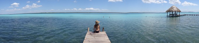
From Mahahual we said farewell to the Caribbean and drove southwest on Ruta 307 to the town of Bacalar (population ~11,000), a Pueblo Magico, located on Lago Bacalar. Per Wikipedia, Bacalar is called the lake of seven colors because of the white sandy bottom that gives the effect of having many shades of blue. It is a freshwater lake feed by underground cenotes, but it looks like the ocean. As described, the water color was stunning and it looked like that of the Caribbean. After a quick visit to the plaza, we found an access point to the lake and jumped in. The water was refreshingly cool, especially given the heat of the day, and being in the stunningly blue freshwater and feeling the silky mud underfoot was marvelous. It was a wonderful last day in the Yucatan.
We had a great time traveling through the Yucatan Peninsula, exploring ancient Mayan ruins, beautiful cenotes and beaches, and interesting towns, viewing amazing wildlife, and meeting new people. During this 15-day section of the road trip, we drove ~1,350 mi (~2173 km), traveling mostly on the free roads (longer but cheaper and often more interesting). We camped all 15 nights (13 nights wild-camping and 2 nights in paid campgrounds, the most expensive being 100 pesos, ~$5). We felt safe the entire time.
And the road trip with my wonderful trip partner Mathieu continues next through the state of Chiapas…stay tuned for upcoming posts!
Here are a few pictures. Click the link to see the full album: https://goo.gl/photos/zNZsL7h7TS2Xztji7
Click this link to see Mathieu’s drone video of the pink flamingos at Rio Lagartos: https://youtu.be/WYI3pOMe1ao
And click this link to see his drone video from Isla Blanca: https://youtu.be/69fWPWOhivo
Enjoy!

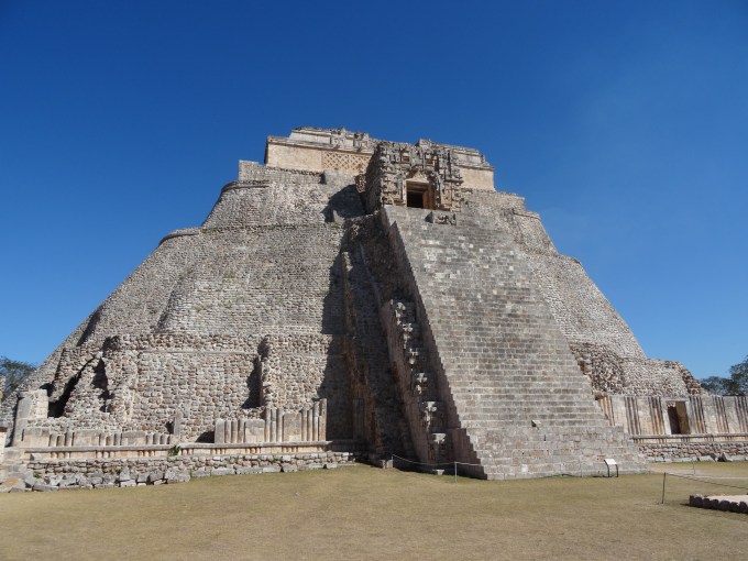
Uxmal ruins.
At the abandoned Cenote Oxola.
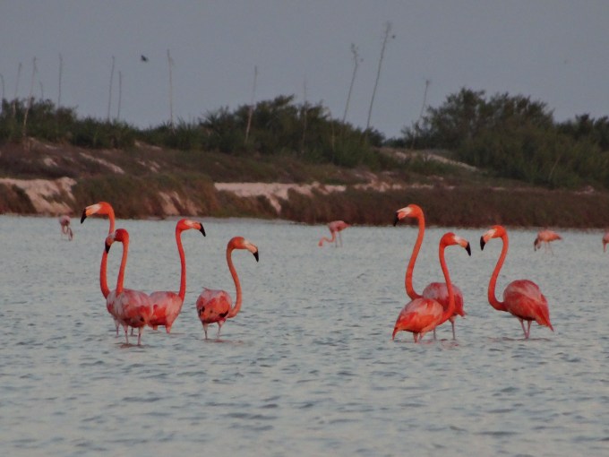
Caribbean flamingos at Reserva Ria Lagartos.

Wild camp spot in Reserva Ria Lagartos.

At Isla Mujeres.
View from our “resort” camping spot at Rio Nizuc Picnic Area, Cancun.

Mathieu kite surfing on Isla Blanca.

Enter a caption
Reserva Biosfera Sian Ka’an.
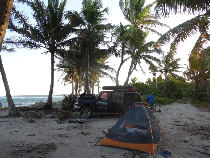
Wild camping in the Reserva Biosfera Sian Ka`an,

Getting ready to snorkel at
Banco Chinchorro.

Me at Banco Chinchorro.
Lago Bacalar. Wow.

Loved Rio Lagartos – did you go to Ek Balaam?
On Wed, Apr 19, 2017 at 10:59 PM, Letting Life Happen wrote:
> Tannika posted: ” After 14 days traveling inland to Campeche (see previous > post), Mathieu and I continued our road trip through Mexico, spending 15 > days on the Yucatan Peninsula in the states of Yucatan and Quintana Roo. > From the coastal city of Campeche, we drove Ruta ” >
LikeLike