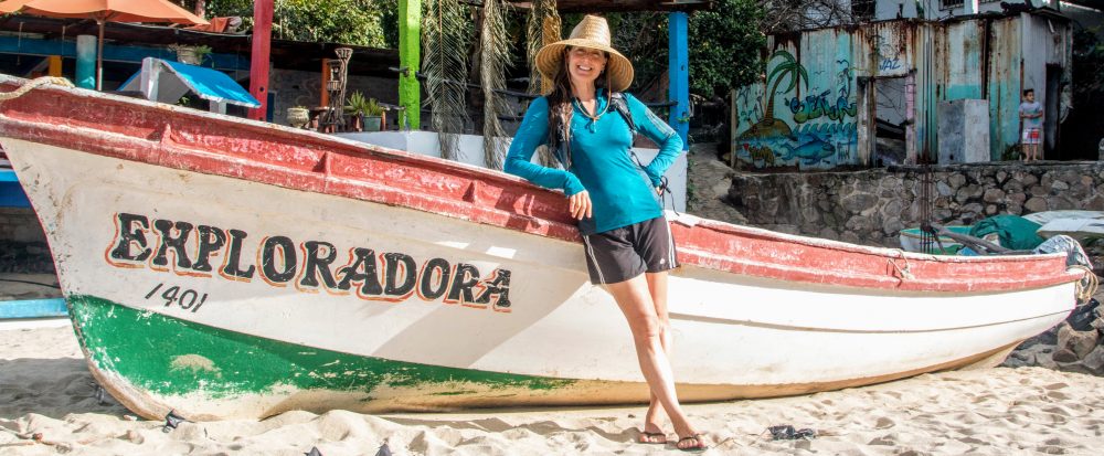

After 17 days traveling inland from the Pacific coast (see previous post), Mathieu and I continued our road trip through Mexico, spending the next 14 days inland in the states of Mexico, Puebla, Tlaxcala, Veracruz and Campeche.
Click HERE to go directly to the full photo album or click “Continue reading” to read more about our road trip adventure through this part of Mexico!
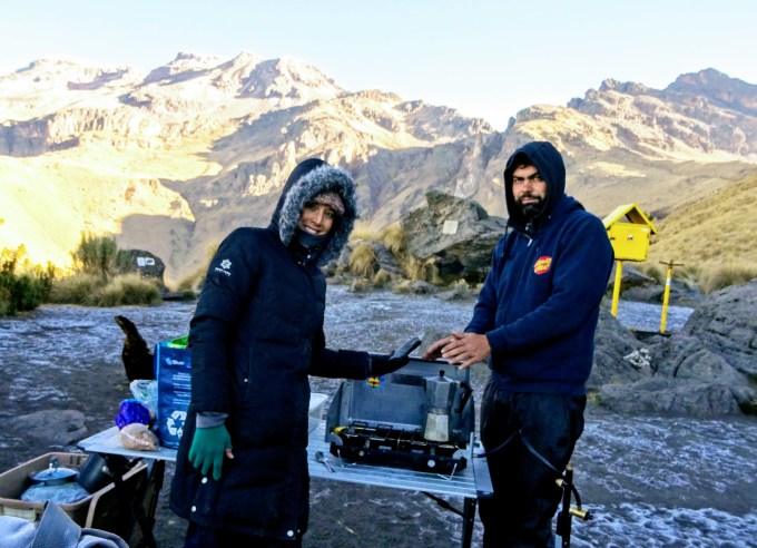
From México City, we drove Rutas 150 and 115 to Parque Nacional Iztaccíhuatl Popocatépetl, a national park straddling the states of México, Puebla, and Morelos. It encompasses Mexico’s second and third-highest peaks, the Popocatépetl (17,802 ft; 5426 m) and Iztaccíhuatl (17,160 ft; 5230 m) volcanoes. Per Wikipedia, the name “Popocatépetl” is Nahuatl for “el cerro que humea” (the hill that smokes). The name “Iztaccíhuatl” is Nahuatl for “mujer blanca” (white woman), reflecting the four individual snow-capped peaks which depict the head, chest, knees and feet of a sleeping female when seen from east or west. We arrived to the park in the late afternoon and drove up the long, bumpy road to set up camp at the trailhead to the peak of the inactive Iztaccíhuatl. The peak of Popocatépetl, an active volcano, was shrouded in clouds but still very impressive and the views of the surrounding valleys were beautiful in the light of the setting sun. Being at 13,040 ft (~4000 m), it was damn cold. Unfortunately, the giant log we hauled to our campsite was damp so Mathieu’s attempt to build a fire was unsuccessful. So after a quick dinner, we climbed into the back of the 4Runner, bundled up in our sleeping bags, and watched a movie until falling asleep.
We woke up to a dusting of ice covering the ground, and while neither of us had slept well due to the high altitude, we felt good. We could see the sunlight on the nearby hills but since we were still in the shadows, we could only imagine its warmth. After breakfast, we loaded up our backpacks with snacks and water then started up the trail. We warmed up quickly as we climbed the steep trail and entered the sun’s path. At the first saddle, we could finally see Popocatépetl or “Popo” for short. True to its name, it was smoking. After a few more hours of hiking up the steep path, Mathieu returned to the truck and I continued solo. We shared the trail with a dozen other hikers but after reaching the small hut at 15,470 ft (4715 m), I had the trail to myself. By now, a thick fog had moved in, periodically covering and uncovering the trail. During the moments that it lifted, the views of the rocky landscape in front of me and of the surrounding valleys were awesome. After almost 2 hours of scrambling up a very steep trail of loose rock, I reached the ridgeline. As I took a moment to rest, the thick fog parted and I could see a large crater below. Since I only had a very general trail map of the area, I didn’t even know there was a crater. Super cool! I continued up along the ridgeline above the crater in hopes of getting to the peak. By 4pm, I hadn’t reached the peak and, per my crappy map, I had no idea how much further it might be so I turned around and started the trek back. I was still enveloped in a thick fog, making it difficult at times to find the trail. Thankfully, the fog parted a few times so I could reassure myself that I was going the right way. Back near the hut, while stopped to double check my route, a fellow hiker came out of the hut and pointed me in the right direction. While I’m sure she was trying to help, I misunderstood her gesturing and went the wrong way. After sliding halfway down the steep, loose rock, I knew I was off the trail. Crap. I went to the right then to the left to see if I could take a shortcut to get back on the trail (and avoid climbing back up the steep “path”). Nope. The other “paths” I investigated ended in steep dropoffs that were likely waterfalls during spring snow melt. Crap. I ate the last of my cookies and powered back up the scree. The side trip had cost me at least 45 minutes and a lot of energy. I shook off the frustration and continued down the correct trail, walking as fast as I could since it was already late. As I went over the final saddle, the sun was setting, casting a lovely light on the surrounding landscape and illuminating Popo. At the trailhead, I was super happy to see Mathieu in the truck waiting for me. It was 7pm by the time I reached him and I was exhausted. It wasn’t a long hike (likely only ~6 mi round trip, but I’d hiked for almost 9 hours, reaching a high point of 16,500 ft (~5000 m). Despite the frustrating trail mishaps (which of course I could have avoided with a proper trail map), it had been a really great day of hiking on another awesome volcano. After the hike, we drove down the mountain and found a hotel with a hot shower and a comfortable bed. I was so tired I fell asleep without eating dinner.
The next day, we drove a secondary road around the volcanos to Cholula (population 120,000; Puebla), visiting the Santuario de la Virgen de los Remedios, a church built by the Spanish atop the ancient Aztec pyramid, Tlachihualtepetl, one of the tallest pyramids of the ancient world at 177 ft (54 m). We walked around this designated Pueblo Magico for almost two hours, and while it was a nice city and the views from the church were nice, neither of us felt the magic.
From there, we continued to the city of Puebla (population 1.4 million), also in the state of Puebla. After the sun set, we rode our bicycles to the city center, getting a taste of the city by night. The next morning, we woke up early, jumping on our bikes to explore this Pueblo Mágico during the day. It was a nice city, with a lovely central plaza lined with restaurants, hotels, small shops, and the beautiful Catedral de Puebla (1649). The cathedral’s two bell towers are just under 300 ft (70 m), the tallest in Mexico. While we were exploring the beautifully ornate church, the organist began playing one of the two massive pipe organs so we were treated to a concert. The sound resonating throughout the church was really beautiful. We also visited the Templo de Santo Domingo and La capilla de la Virgen del Rosario. The Santo Domingo church was nice, as they usually are, but upon taking a left turn to visit the Capilla Rosario, a small adjoining room of the main church…wow! The entire room was painted gold and so ornate that it was difficult for the eye to find a focal point. Per Wikipedia, la capilla, described as “The House of Gold”, constitutes one of the most outstanding examples of Baroque Novohispano architecture and one of the greatest artistic-religious achievements of Mexico. We took pictures and just sat absorbing the scene for at least 30 minutes. From there, we continued our bicycle tour, visiting the Biblioteca Palafoxiana, a private collection donated to the public in 1646, making it the first public library in Latin America. The library has more than 41,000 books and manuscripts, ranging from the 15th to the 20th century, and is a UNESCO World Heritage Site. After, we biked through a few small parks then to El Parin, a street market lined with stalls selling various souvenirs and handicrafts. It was a nice tour through a lovely city.
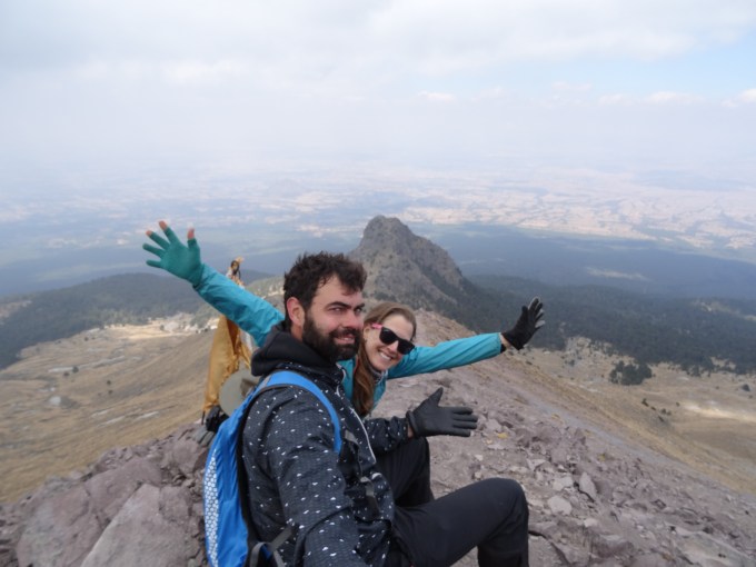
From Puebla, we drove north on secondary roads to Parque Nacional La Malinche straddling the states of Puebla and Tlaxcala. The national park encompassing the inactive La Malinche volcano, the sixth highest peak in Mexico at 14,567 ft (4440 m). Per Wikipedia, the volcano was named in honor of Malinche, a Nahua woman from the Mexican Gulf Coast who helped the Spanish conquistador, Hernán Cortés, as an interpreter during the conquest of the Aztec Empire and later became his mistress. She has been historically portrayed both as a traitor and as the mother of new race. We set up camp in the forest near the trailhead. It was cold but bearable since we were at 10,170 ft (3100 m), not as high up as the last volcano, and there was plenty of dry wood for Mathieu to build a raging fire. While cooking dinner, we were joined by a friendly yellow dog. We gave her some food and in return, she guarded the area around us all night, chasing off any dangerous animals (aka man-eating squirrels) that tried to get close to us.
The next morning, the three of us (me, Mathieu, and our new dog friend) started up the trail to the summit. The trail was steep, going straight up through the forest to the base of the volcano, only then did it zig zag a bit. Trekking through the pine forest was lovely but the views of the surrounding area as we climbed up the side of the volcano were stunning. We stopped for a snack then, while Mathieu and our dog friend enjoyed the view, I continued up the last section. Thankfully, the path was well-worn, not requiring a map. After walking up the ridgeline for about 30 minutes, I reached the summit and was rewarded with a view of the eroded crater below and of the surrounding hills and valleys. And I had the summit to myself. Back at the truck, we gave our dog friend more food then said farewell. She’d been a great trekking partner on the 6-hour, ~8-mi (~13-km) hike to 14,567 ft (4440 m). From there, we drove for about an hour then stopped for the night at a roadside auto motel in the tiny town of Cuapiaxtla (in the state of Tlaxcala). The room was very cheap but clean and had a hot shower and a comfortable bed. And, while the TV only had one channel, it was a porn channel, an amenity the manager made sure to tell us when we checked in. Too bad I fell asleep immediately after my hot shower. Ha!
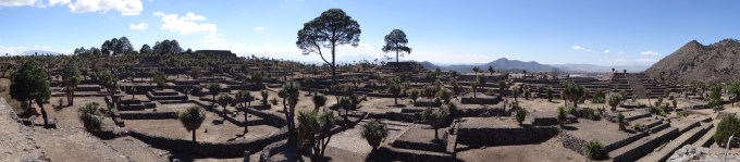
The next day, we continued on Ruta 129 and secondary roads to Cantona (Puebla). Per Wikipedia, Cantona is the largest pre-Hispanic city yet discovered in Mesoamerica, occupying an area of 4.6 sq mi (12 sq km). The site, occupied from ~900 BC to 1050 AD, comprises a road network with over 500 cobblestone causeways, more than 3,000 individual patios, residences, 24 ball courts and an elaborate acropolis with multiple ceremonial buildings and temples. The buildings were constructed with carved stones (one atop the other) without any stucco or cement mortar. At its peak, the population is estimated at about 80,000 inhabitants. We spent a few hours walking around the huge site, strolling along the ancient cobblestone streets and climbing the steep steps of the few accessible temples trying to imagine what life there had been like. Luckily, we shared the impressive site with only a handful of other tourists (all domestic), allowing us the solitude to feel the history of the place.
From the ruins, we drove northeast on Ruta 140 to the Gulf of Mexico, After a rainy, foggy 3-hour drive through the mountains, we got to the city of Cardel where we then drove Ruta 180 north to Punta Mancha. We drove around for about an hour trying to find access to a beach to camp on (per iOverlander). Thankfully a nice policeman who’d stopped us while we were driving illegally through government property gave us directions to another public beach to the north where we could camp. After a 30 minute drive, we found Playa Villa Rica and set up camp. It was late (~9:30pm) so the beach was quiet but given the number of palapas and pongas (small boats) on the beach, it was clear this was a popular beach. There were a few people gathered around distant bonfires up and down the beach, but we were otherwise alone. This was our first stop and Mathieu’s first time at the Gulf of Mexico. We sat on the beach and celebrated with a bottle of red wine.
The next day, we enjoyed the serenity of the early morning, watching the sun rise and the shorebirds fish. Then at about 10am, the masses started to arrive. It was Sunday funday and large groups of families and friends congregated around the palapas up and down the beach. Since we’d strategically set up camp away from the palapas, our little patch of beach remained relatively tranquil. Despite the crowds, the beach was nice and the weather was mild, so we decided to spend another night at that spot. We had a leisurely day reading, journaling, swimming, and people watching. It felt good to have a chill day on the beach.
From Playa Villa Rica, we drove Ruta 180 south along the coast to Veracruz (population ~428,300; Veracruz). While the state capital was a nice city, we’d seen enough after two hours so continued south on Ruta 180. The coastal drive was lovely, passing areas of grassy coastal dunes and crossing large lagoons. After the turnoff to Ruta 175, we crossed the wide Rio Papaloapan then paralleled it as we continued to the small town of Tlacotalpan (population 8,853; Veracruz). The drive along the river was especially pretty, reminding me of the lush green gulf coasts of Texas and Louisiana. Tlacotalpan is a designated Pueblo Magico and, per Wikipedia, is a UNESCO World Heritage Site for for its Spanish/Caribbean architecture and colonial-era layout. With its brightly-colored colonial-style buildings and lovely central plaza, it was a very charming town. We enjoyed walking along the riverfront and through the small, quiet residential streets and the street market where vendors sold souvenirs, handmade jewelry and embroidered clothes. The town was very tranquil with only a few dozen tourists (almost entirely domestic) eating at the riverfront restaurants, shopping at the market, or enjoying the plaza. The small town, especially given its location on the beautiful river, was a truly magical city.
From Tlacotalpan, we returned to Ruta 180 and drove further south to Balneario Cinco Chorros (Veracruz), a riverside campground we’d read about on iOverlander. We arrived after dark and set up camp under the large trees. We fell asleep to the sound of the nearby river. The next morning we got to see the beautiful river and the five small waterfalls we’d read about. We had the entire place to ourselves and spent several hours playing in the river and jumping from the waterfalls. It was a great way to start the day.
After playing in the river, we continued on Ruta 180 to Catemaco (population 27,615; Veracruz), a Pueblo Magico located on Lago Catemaco, a large lake surrounded by small mountains. Per Wikipedia, Catemaco is a tourist destination which besides the lake and remnants of the region’s rainforest, is known for its tradition of sorcery/witchcraft that has its roots in the preHispanic period and is mostly practiced by men. This tradition is well known in Mexico and attracts clients from various walks of life, including businessmen and national level politicians. Catemaco holds an annual event in March dedicated to sorcery which can draw up to 5,000 visitors. Interesting. Unfortunately during our short stop we didn’t witness anyone practicing sorcery or witchcraft (as least to our knowledge) and, while it had a relaxed vibe, we found the town less than magical. The river, however, was beautiful so we decided to drive around it to Poza Reina, a deep pool in the river we’d read about in our guidebook. As we continued along the lake road, we passed through thick tropical forest and lush pasture dotted with munching cows. After a few miles, the road deteriorated and became potholed and slow going. We passed a handful of other vehicles during our drive but we were definitely the only tourists. After a bit, we turned away from the lake and up the hilly road toward the pool. Poza Reina was on private property that was part of a reserve. Once parked, we were greeted by a friendly woman, the landowner, and her three kids. After paying a small fee to enter, we parked in front of the family’s house, then followed the dirt trail through the thick forest to a large deep natural pool below a small waterfall. Wow! And….we had it all to ourselves. We jumped in and played, swimming around and jumping off the rocks for over two hours. We would have stayed longer but it was already 5pm and the pool was now shaded, making it harder to warm up after swimming in the cool water.
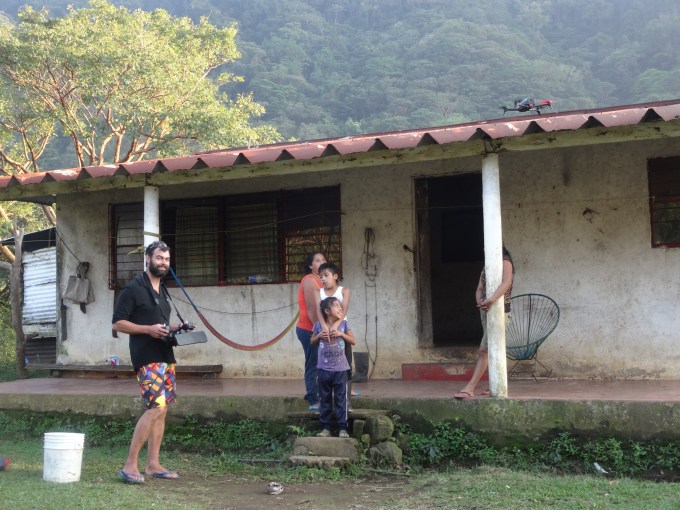
Our entry fee also included a guided tour to another waterfall, Cola de Caballo. The woman’s young son, Salvador (~8 years old), served as our guide. We re-arranged the stuff in the 4Runner to make a seat for him and off we went. The three of us ate chocolate cookies during the short drive and we peppered Salvador with questions about school and what he liked to do for fun. Once at the trailhead, our young guide lead us down the hill and along the river to the waterfall. It was impressive, being ~100 ft (~30 m) high. After admiring the falls for a bit, we sensed that Salvador would rather be playing then hanging with us so we followed him back to the truck and returned him home. Once back, Mathieu showed the mom and her kids the drone videos he’d taken at the pool and the waterfall. They loved the videos. Finding out they didn’t know what a drone was, Mathieu gave them a demonstration. The family’s wide eyes and laughter were priceless. They loved it and we all laughed as their two dogs, one a puppy, ran from it barking. At the end of the demonstration, Mathieu showed them the video of them and their house which they really loved. Since it was already early evening and we were in a wonderful place, we ended up camping (with the family’s consent) near the trail to the waterfall. We couldn’t see the pool from our campsite but we could hear the thundering water. Given the sound of the water and the light of the nearly full moon, it was a lovely night.
After an early morning swim in the refreshing pool, we continued around the lake, driving through the tiny lakeside village of La Margarita before going up and over the hills and driving through several more tiny villages before rejoining Ruta 180. We drove southeast about 7 hours on Rutas 180, 186, and 199 to a campground near the famous archeological site of Palanche (in the state of Chiapas). Long day! After setting up camp, we enjoyed the music being played by the group next to us. There was a drummer, a guitar player, a trumpet player, and a singer. They sounded pretty good. It was nice to have live music while relaxing under the stars.
The next morning, we got up early to visit the ruins. Per Wikipedia, Palenque is the site of a Mayan city that flourished in the 7th century and contains some of the finest architecture, sculpture, roof comb and bas-relief carvings that the Mayas produced. The most famous ruler of Palenque was K’inich Janaab Pakal, or Pacal the Great whose tomb was found in the Temple of Inscriptions. By 2005, the discovered area covered up to 2.5 km² (1 sq mi), but it is estimated that less than 10% of the total area of the city is explored, leaving more than a thousand structures still covered by jungle. It was amazing to see these large enduring structures built around 600 BC and found after centuries of being hidden in the jungle. We spent almost 4 hours walking around the site, going up any structures we were allowed to climb. While there were many other tourists, the site was not at all crowded, giving everyone plenty of space to ponder what life had been like there. We especially enjoyed seeing the Temple of the Inscriptions where Pacal the Great had been buried. We’d been introduced to Pacal when we visited an exhibit dedicated to him that included his jade death mask and a replica of the sarcophagal lid from his tomb at a museum in Mexico City. It was great to now visit the city he was famous for ruling. After our tour of the ruins, we stopped at the nearby Cascada Misol-Ha, a 115-ft (35-m) high waterfall to cool off then rejoined Ruta 180, driving along the Gulf of Mexico to Campeche. In route to Ruta 180, we passed through monkey habitat. There were signs along the highway cautioning drivers about the presence of the monkeys and there were monkey crossing bridges, small bridges suspended over the highway. It was great to see the conservation efforts.
The coastal city of Campeche (population ~900,000) is the capital of the state of Campeche. Per wikipedia, the walled city is UNESCO World Heritage Site and is one of the least known and unrated colonial cities in Mexico, mostly bypassed by those visiting more famous destinations in the Yucatan peninsula. Campeche was one of the most important ports in New Spain. It suffered more than twenty one major pirate attacks in the colonial era. After 1685, the city’s main fortifications were begun taking 24 years to complete. They succeeded in stopping major pirate attacks, with only one, Barbillas, finding a way to enter the city in 1708.
We both found the city’s narrow streets and brightly-colored buildings charming. And who doesn’t love a city with fortresses and real pirate stories. More than twenty one major pirate attacks! We enjoyed walking along the lovely malecon, walking on top of the fortress walls, reading real accounts of some of the many pirate attacks on the city at the local museum, and chilling in the central plaza (directly across from our hotel). We ended up staying in Campeche for 5 nights.
While we really liked the charming, relaxed city, part of the reason for our extended stay was medical. By the time we got there, Mathieu’s tooth had become increasingly painful. Since Campeche was a large city, it seemed like a good place to find a dentist. His dental treatment was successful but only after three visits to two different dentists. The first dentist filled a small cavity that Mathieu didn’t know he had but didn’t treat the tooth causing the pain. When he returned to this dentist, he filled another small cavity Mathieu was unaware of but still didn’t treat the painful tooth. Unfortunately the dentist’s reasons for avoiding the problem tooth were lost in the language difference. After getting a glowing recommendation from our waitress during dinner, Mathieu visited a second dentist. Again he returned untreated but this time he understood the reason. He had an infection under a crown. He’d have to take antibiotics to decrease the swelling before the dentist could proceed. After a 24-hour period of taking antibiotics, he returned to his new dentist. She tried in vain to get the crown off but was unsuccessful. For some reason, I have an image of her with her feet pushing against Mathieu’s chair for extra torque as she yanks furiously to get the crown off. Ha! She prescribed him anti-inflammatories and painkillers to go with the antibiotics and recommended he see another dentist when he completed the 30-day regimen of antibiotics. Thankfully, the medicines worked instantly to decrease the pain and the need, so far, to visit another dentist while traveling.
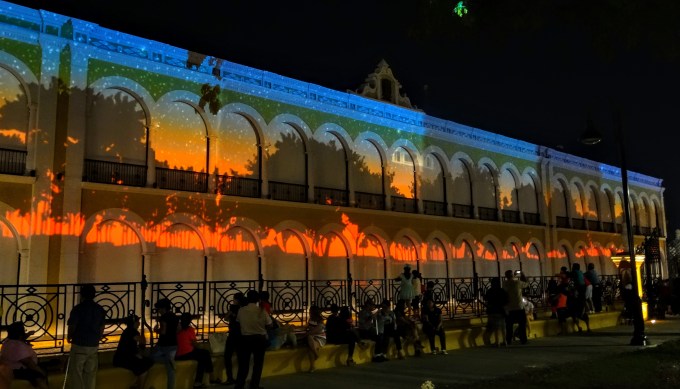
Between dental appointments and trips to the pharmacy, we continued to explore the city and also used the time to relax, read, and journal in our comfortable, air conditioned room. On the Saturday night, we heard loud music outside the hotel. Looking out, we saw that a movie was being projected onto the block-long, beautiful Palacial Municiple that fronted one whole side of the plaza. It was an animated movie portraying the history of Campeche. It was super colorful and had a great soundtrack that blared from high-quality speakers. It was really fun to sit among the crowd gathered in the plaza and enjoy the show. Bravo!
The following night, there was another event. We’d been visiting the local mercado but upon returning to the hotel, saw the end of what appeared to be a beauty pageant. We could see a dozen young ladies, all beautiful in their sequined gowns and tiaras, being photographed off the small stage. The mood was very festive. The crowd was a mix of locals and foreigners. While we saw many foreign tourists while there, our numbers were relatively few. As we returned to our hotel, they replayed the animated movie from the previous night. We went to the roof of our hotel with a small glass of tequila each to watch. It was just as enjoyable the second time.
We had a great time traveling through more of inland Mexico, hiking more volcanoes, exploring more charming, interesting cities and towns, and meeting new people. During this 14-day section of the road trip, we drove ~1,100 mi (~1680 km), traveling mostly on the free roads (longer but cheaper and often more interesting). We stayed in hotels for 7 nights (the most expensive being 400 pesos, ~$21) and camped 7 nights (5 nights wild-camping in our tent or the back of the 4Runner and 2 nights in paid campgrounds, the most expensive being 100 pesos, ~$5). We felt safe the entire time.
And the road trip with my wonderful road trip partner Mathieu continues next through the Yucatan Peninsula…stay tuned for upcoming posts!
Here are a few pictures. Click the link to see the full album: https://goo.gl/photos/UBSRS9FduvFGgXSTA
And click this link to see Mathieu’s drone video of the colorful town of Tlacotalpan: https://m.youtube.com/watch?v=eHAxgwI
Enjoy!


Good morning Volcan Iztaccihuatl.
Warming up before hiking Iztaccíhuatl.

La capilla de la Virgen del Rosario, “the House of Gold”, Puebla.

Through the forest on volcan La Malinche with our hiking partner.
Volcan La Malinche – almost there.
Cantona ruins.

Chill day at Playa Villa Rica, Gulf of Mexico.

The colorful Tlacotalpan.

Water play at Balneario Cinco Chorros.
Drone demo with Salvador and his family. Priceless.

At Poza Reina.

Temple of Inscriptions, burial site of Pacal the Great in Palenque.

Hello Campeche!

A modern-day pirate. Argh…
An animated movie shown on the Palacial Municiple. Awesome!

Hey T,
It’s Steffen, your hiking buddy from Puerto Natales. Sometimes I think back to the good times we had. And good to see you are still on the road.
I have been caught by the boring corporate life again. Accepted a very traditional full time job in IT. But it works for me. At least for now 🙂
Would love to catch up some day.
Best
Steffen
LikeLike
Hi Steffen, thanks for reading my blog! I often think back to our trek together at Torres del Paine. I hope we can trek together again someday!
LikeLike
Mathieu’s beard is looking awesome! Great read T. I guess i was really behind. Gonna catch up on some of your past posts. let’s try to talking again this week if you can. love you.
LikeLike
Hi Angel, thanks for reading my blog! Yeah, the beard was fierce. He has since shaved it but I’m sure it’ll be back again during our road trip. Ha! Love you too.
LikeLike
Mountains, valcanoes, rivers, forests, beautiful plazas, great food and friendly people. Is there no end to having a fabulous travel adventure? I certainly hope not!!! Journey safely, Dad
LikeLike
Pingback: Mexico – Part 4: More Volcanoes, Ruins, and Cities Big & Small (Mexico City to Campeche; Jan 30 to Feb 13, 2017) — Letting Life Happen - Turista Mexico