
Last May, with the return of Spring to the Drome Valley (our home in France), it was time to enjoy the warmer weather and take a road trip. Mathieu and I packed the side and top boxes of his Triumph Tiger motorcycle with basic camping gear and some clothes, and drove about 3.5 hours to the coastal city of Nice. There, we loaded the motorcycle and ourselves onto the Moby Zaza, a overnight ferry adorned, oddly, with Looney Tunes characters (e.g., Tweety Bird, Wile E. Coyote) that took us to the island of Corsica (Corse in French).
Click HERE to go directly to the full photo album or click “Continue reading” to find out more about our 9-day moto adventure!
The Mediterranean island of Corsica (population 330,000) is one of the 18 regions of France. Its residents are renowned for being defiant and fiercely nationalistic, wanting the originality of the culture and language acknowledged and protected. While French is the official language, the Corsican language is still spoken, and signposts give place names in both languages. Napoleon Bonaparte, born in 1769 in the Corsican capital of Ajaccio, is the island’s most famous export [1,2,3].
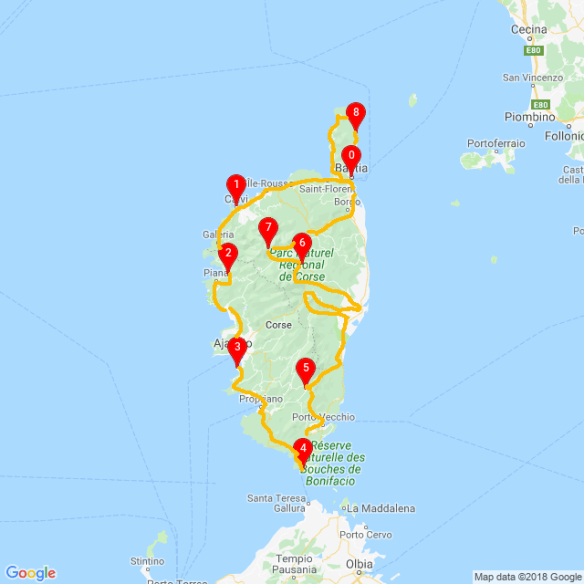
After arriving the next morning in the port city of Bastia, we started our adventure. We spent the next 9 days exploring the 114-mi (183-km) long, 52-mi (83-km) wide island, driving counterclockwise along the island’s narrow coastal roads and through the mountainous interior.
Our first stop was Desert des Agriates, a 2,355-ac (5,000-ha) protected area of rocky scrubland on the northwest coast. Being my first time on a dirt track via motorcycle, I was a bit nervous as we started down the unmaintained road. To calm my nerves, Mathieu, a very experienced moto driver, reassured me with “try not to be stressed if we fall; it may happen” then further explained that since we’d be going slow, we’d fall slowly and that at worst, my leg could get caught under the moto, but I wouldn’t likely get hurt. Uh…ok… We didn’t fall, and instead had a bumpy, muddy ride through a beautiful rocky plateau dotted with areas of dense green shrubs. The road ended at Plage du Saleccia, a gorgeous white-sand beach enjoyed by sunbathing tourists and cows. The views of the turquoise sea were beautiful.
The next morning, we explored the city of Calvi, walking to the medieval fortress overlooking the sparkling sea. We walked the cobblestone streets and visited the ancient cathedral. From the cliff top, we saw, for the first time, the massive peaks of the single mountain chain that makes up two-thirds of the island. I knew there were tall peaks in Corsica but was surprised to see so much snow!
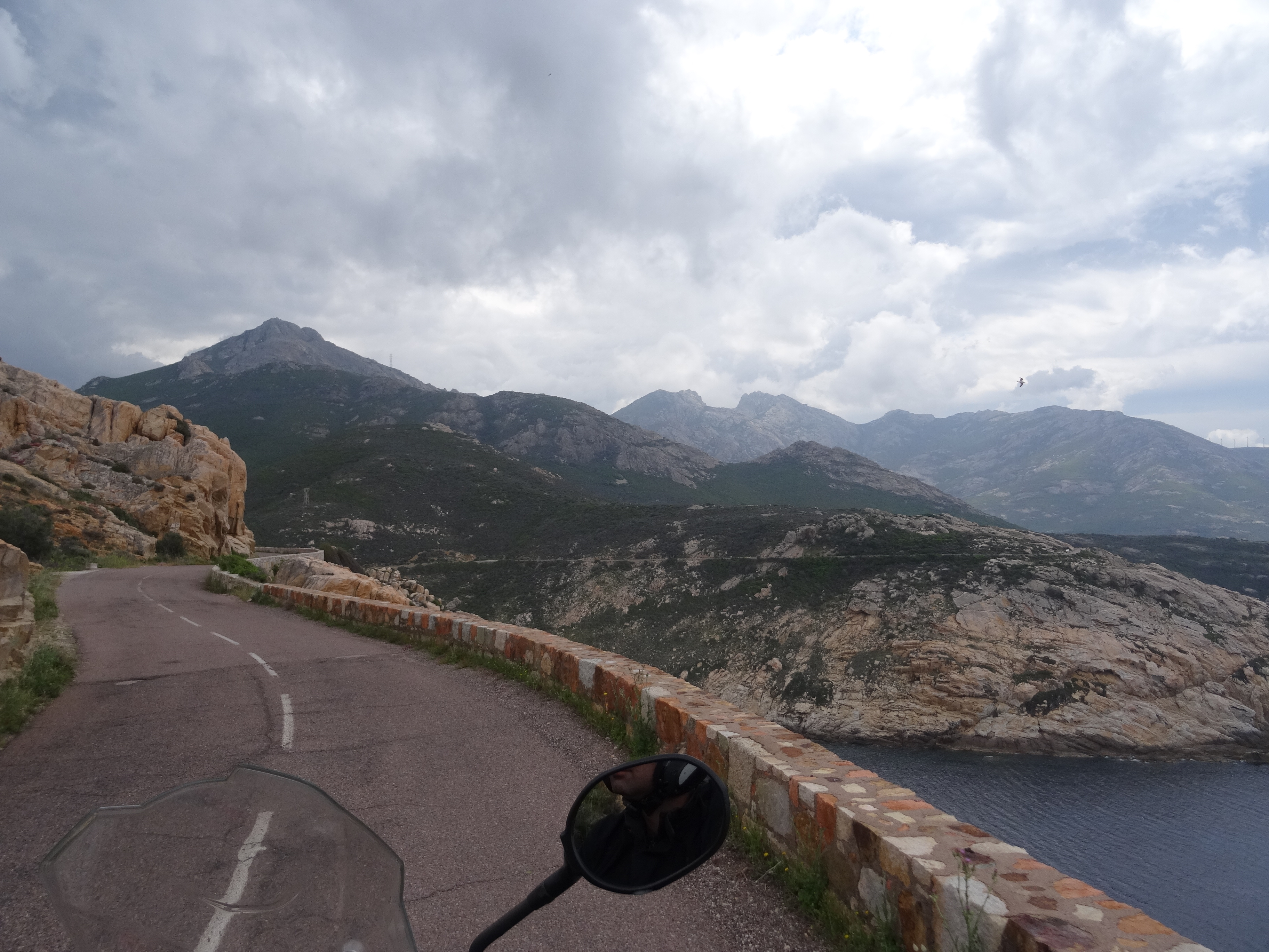
From Calvi, we continued south on the curvy, narrow coastal road along red-colored cliffs that dropped steeply into the sea below. The views were stunning. As we continued to the village of Porto, the storm clouds that were chasing us finally caught up and “il pleuvait comme la vache qui a pissé” (“it rained like the cow who pissed”). After realizing the rain would continue through the night, we rented a cozy bungalow (the only night we spent out of our tiny, 2-person tent). We cranked the heater, hung up our wet clothes and gear in every available space, then walked through Porto, a UNESCO World Heritage site. The coastal village consists mostly of shops, restaurants, and hotels for tourists but it’s charming and ideally situated where the river meets the sea.
The rain finally lessened around noon the next day and we were able to hit the road again. We drove inland on a narrow, curvy road overlooking the Gorges de Spelunca, a deep rivercut-canyon, then continued higher into the mountains to Col de Vergio, a pass at 4,850 ft (1478 m). However, after about 20 minutes, we started to see snow on the ground and it started to hail. We took a few ”we were here” pics and quickly backtracked to the coast. The weather remained stormy all day but with the addition of the 5€ rain poncho I’d bought in Porto, I kept mostly dry, and the views of the dark, dramatic sea as we continued driving south kept us both mesmerized.
After another rainy night (now back in our tent), we continued along the coast to Bonifacio, at the southern tip of the island. This medieval town was built on the site of a 9th century fortress on top of precipitous outcrop of white limestone 230 ft (70 m) above the sea. It was stunning! We walked through the gates of the Bastion de k`Etendard, the 1,000-year old fortress that used to protect the adjacent harbor, and explored la Haute Ville (the upper city). While touristy, the old town still consists primarily of occupied residences. It was fun to imagine living in such a fairy-tale place, to walk or drive through town on the narrow, cobblestone streets to buy a daily baguette, or to exit the city walls and descend the steep road to shop in the modern, bustling marina area below.
While in the upper city, we climbed down the Escalier du Roy D’Aragon, a steep stairway commissioned in 1420 by the King of Aragon consisting of 187 steps leading to a pathway along the side of the cliffs providing locals access to an underground freshwater well. The locals must have had legs of steel after climbing back up those super steep steps loaded with buckets of water! From the cliff top, we could also see the Italian island of Sardinia, only 7 mi (11 km) across the Strait of Bonifacio. Bonifacio was by far our favorite city in Corsica, and one of the most magical French cities I’ve visited so far.
The next day, we started the drive north to explore the eastern side of the island. After a quick stop at Plage de Palombaggia, another lovely white-sand beach, and a short walk through the city of Porto-Vecchio (which turned out to be less charming then we’d read about), we drove into the mountains to visit Cascade Piscia di Ghjaddu. Despite the cloudy, cool weather, the 45-minute hike through the forested, rocky landscape was wonderful, and the nearly 200-ft (60-m) tall waterfall, a forceful stream of water gushing out of a large gap in the rock, was impressive. Back in the parking lot, we met a local guy who came over to check that all was okay (since it was now after dark). After he and Mathieu chatted about motorcycles (a shared passion) and life in Corsica, he directed us to a back parking lot where we could wild camp. By now, the clouds had cleared and we finally enjoyed a sky full of stars.
In the morning, we continued north through the mountains to Aiguilles de Bavella, an area of massive, jagged peaks, steep rock walls, and wind-twisted pine trees. The large parking lot full of cars and tour buses confirmed it was a popular attraction. We climbed up a steep, less-popular trail to avoid the masses. By the time we got to the top, we had only 5 minutes before the wet, dense fog swallowed us up. Thankfully we’d gotten a glimpse of the dramatic landscape surrounding us. After the hike, we drove along a narrow, deep canyon back down to the coast, and back to warmer weather. Apparently the sunny coastal weather rejuvenated us because an hour later, we drove back into the mountains and risked freezing our butts off again. Ha!
We drove through Defile de I’Inzecca, another beautiful, deep, river-cut canyon. As we continued higher, the weather, as predicted, became cold and foggy again so upon reaching the top of the canyon, we drove back to the coast. This time, the route back to the coast was a single-lane road that took us through rolling hills, pastures, and quaint farmhouses. We’d intended to camp along the coast that night but missed a turn and ended up driving back toward the mountains. So, we found a nice campground and drank a beer while reminiscing about our adventurous day being alternately cold and warm as we zig-zagged from the mountains to the coast, back to the mountains, back to the coast, and finally back to the mountains. Ha!
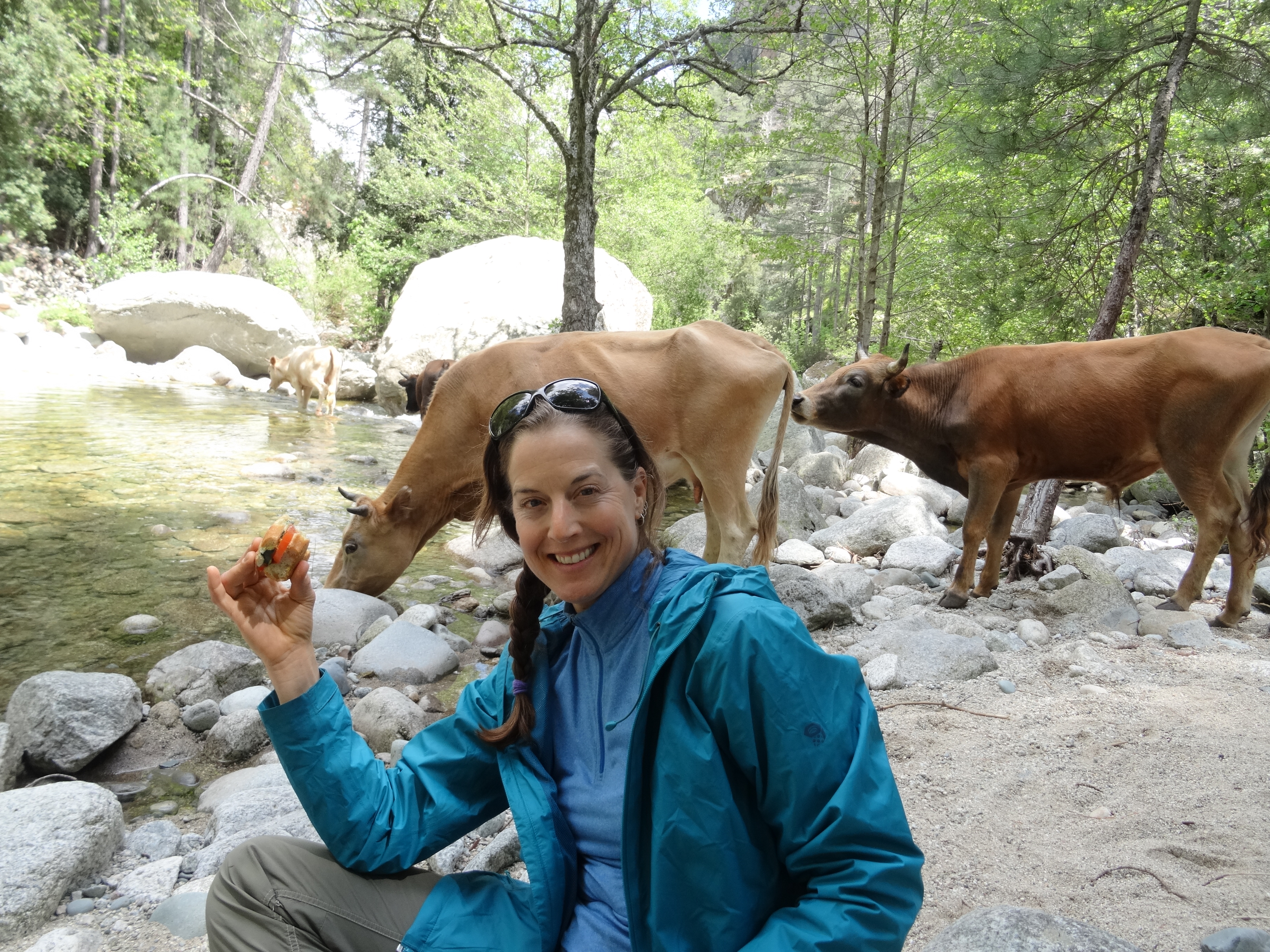
The next morning, bathed in sunlight, we drove through the Gorges du Tavignano, another beautiful, deep canyon. We stopped in the city of Corte. After a stroll through the cobblestone streets of the old part of town, we went for a long hike into the Gorge. It felt good to be in the sun again and the views of the canyon and river below were beautiful. While we enjoyed a post-hike lemonade and looked at the map for our next destination, I decided we had to hike to Monte Cinto. I knew it would be very cold but I couldn’t leave Corsica without trying to climb its highest mountain at 8,878 ft (2,706 m). So, from Corte, we drove through Gorges de Asco, another beautiful, deep canyon and found a small campground en route to the mountains. I was like a kid the night before going to Disneyland; excited.
We left early the next morning to the trailhead to Monte Cintu. The trail is part of the GR20, a long distance trail traversing Corsica diagonally from north to south. It is considered to be the most difficult of all the GR routes and one of the most beautiful mountain trails in Europe [4].
Completing the 112-mi (180-km) GR20 is on my “to do list” so I was excited to get a glimpse of the landscape I would someday encounter. The trail took us quickly out of the forest and up a wide, rocky valley toward the snow-covered peaks. There were metal chains in some sections so you could pull yourself up the steep rock face (presumably in times of ice and snow on the trail). It was super fun. As we climbed higher, we encountered increasing larger snow patches and eventually arrived to what appeared to be the beginning of the snowline. Since we didn’t have proper snow gear (e.g., crampons and ice axes) or any knowledge of the trail conditions higher up, or even a good map of the area, this was our stopping point. No worries. I’d be back.
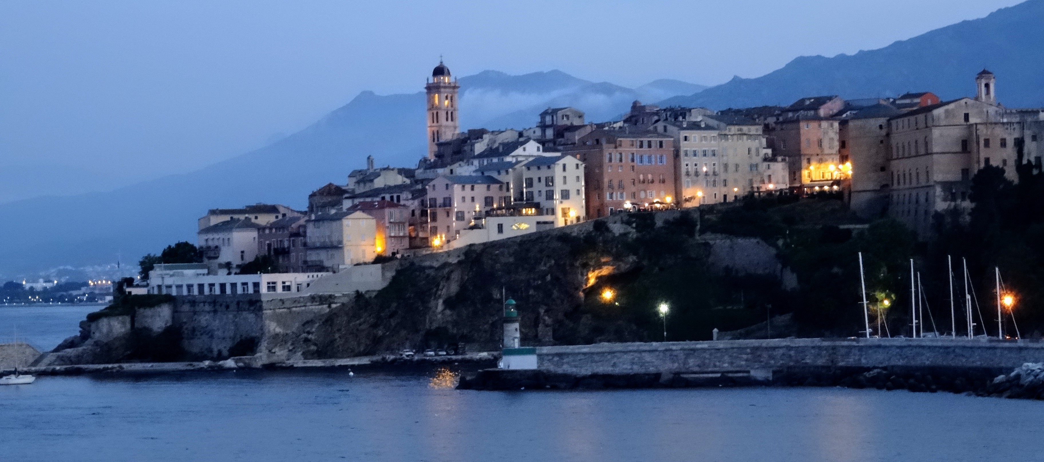
We enjoyed the stunning views for awhile, then started the trek back. About halfway down, the sunny weather changed and the mountain peaks were suddenly engulfed by low, dense clouds. By the time we got back to the parking lot, it was raining hard. Road tripping via moto is great until…it rains. We hung out at the only restaurant near the trailhead for about an hour then took advantage of a break in the weather to drive back to the coast and back to dry, warm weather. We drove through Bastia, where we’d landed 8 days before, then continued north to Cap Corse, a narrow peninsula jutting out from the northern tip of the island.
I got up early the next morning to watch a beautiful sunrise. It was our last day in Corsica. If we’d planned it right, we could have watched the sun rise on the east coast of Cap Corse then had a leisurely drive around the peninsula and watched the sun set on the west coast. Next time. Thankfully, we had plenty of time to enjoy the beautiful scenery along the narrow coastal road, explore the quaint, coastal towns, have a beach picnic, and to toast one last drink at a roadside cafe overlooking the sparkling Mediterranean Sea.
Later that night, we returned to Bastia and re-boarded the Moby Zaza for our trip back to mainland France. As we stood on the deck of the ferry, we reminisced about our moto road trip around this lovely island and agreed we’d be back. Au revoir l’Ile de Beauté. Until next time.
Here are a few pictures. Click the link to see the full album of pictures and videos: https://photos.app.goo.gl/4TrxUPetVoaDCG9N8
Enjoy!
[Next post: Road trip through the French Alps. Stay tuned.]


Magnificent photos! I never realized we needed to visit Corsica – now I do! love, Aunt Pat
LikeLike
Amazing place. Great photos! Wonderful to see you guys having another HIGH adventure exploring the world. Tons, DAD
LikeLike
Wow! You are living life to the fullest! I’m jealous
LikeLike
Great journey : will have to do it again !!!!
LikeLike